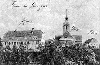
Grove (Neukieritzsch)
Hain (formerly also Hayn ) was a village south of Leipzig that fell victim to lignite mining between 1968 and 1971 as a result of the Witznitz II opencast mine . From 1948 his neighboring village Kreudnitz was incorporated into Hain. In 1971 the corridor of the devastated village of Hain was classified according to Kahnsdorf . Today the Hain corridor belongs to the Neukieritzsch community . Hain is the namesake for the Hainer See , which was created after the flooding of a residual open pit.
location
Hain lay between Rötha in the northwest and Borna in the southeast in the southern part of the Leipzig lowland bay . The former post road from Leipzig to Altenburg ran through the village, following the route of the medieval trade route Via Imperii . Hain lost this connection on this road with the construction of the higher-lying trunk road via Espenhain at the beginning of the 19th century. Gutengröba in the north-east belonged to Hain from time immemorial, which consisted of the Gröbamühle on the Pleiße and the Bergschänke restaurant on Poststrasse. Between Gutengröba and Hain, the Poststrasse ran through the valley of the Langer Born brook.
Hain was located on sloping terrain on the east bank of the Pleiße , which is why its field corridor extended to the east and was to be found in the west over the Pleiße in the meadow meadow. South of Hain, the Wyhra formerly flowed into the Pleiße. The surrounding places were from the north clockwise Kreudnitz, Espenhain, Groß- and Kleinzössen , Kahnsdorf with Zöpen and Pürsten, Trachenau with Treppendorf and Gaulis .
The former location of Hain is today in the north of the Hainer See, southwest of the northern beach belonging to Rötha. The Hainer See belongs to the Leipziger Neuseenland .
history
The folk legend has it that formerly around a Raubschloss have stood, but that could not be detected. Only a few field names are an indication of this.
The first written mention of Hain in 1350 is related to the patronage law , from which the existence of a church or chapel can be concluded. Since 1465, Hain belonged to the manor Großzössen .
Church news has only been available since the time of the Reformation , which was introduced in Hain between 1528 and 1533. These show that Georg Spalatin carried out church visits in Hain . In 1543 the parishes of Hayn and Kreudnitz were amalgamated under one priest as equal rights, and the right of patronage went alternately to Großzössen and Rötha. The last Hainer church was built in 1688/89 after the previous one had been repeatedly reconstructed after fire damage. The simple structure had a baroque style tower with a clock and three bells, which was designed as a roof turret .
Hain with the associated Gutengröba was in the Electoral Saxon or Royal Saxon Office of Borna until 1856 . From 1856 Hain belonged to the Rötha court office and from 1875 to the Borna district administration . On September 1, 1948, Kreudnitz was incorporated into Hain.
For a long time, Hain remained untouched by lignite mining in the Borna district. This changed after construction site 2 was opened in the south-western Witznitz II opencast mine in 1960 with the construction of the Kahnsdorf pivot point . In preparation for coal mining, the Pleiße in the west was led around the opencast mine in 1963/64, Kreudnitz was closed in 1968 and its corridors were dredged over until 1971. At the same time as Hain, the demolition of Kleinzössen took place . In 1971 the Hainer Ortsflur came to Kahnsdorf, with it in 1994 to Lobstädt and finally in 2008 to Neukieritzsch.
The change in economic policy that accompanied the German reunification in 1989/90 led to a drastic decline in the demand for lignite, as a result of which the Witznitz II open-cast mine was closed prematurely by 1993 despite the presence of deposits. The Hainer See, named after Hain, developed from a renatured residual hole, which reached its final water level in 2010. North of the former location of Hain, the north beach Rötha is currently being built, a leisure facility with a harbor, holiday home area and camping site.
Web links
- Hain in the Digital Historical Directory of Saxony
- Gutengröba in the Digital Historical Directory of Saxony
Individual evidence
- ↑ a b c New Saxon Church Gallery. The ephorie Borna. Leipzig 1903 pp. 491-510
- ^ The manor Großzössen in the state archive of Saxony
- ^ Karlheinz Blaschke , Uwe Ulrich Jäschke : Kursächsischer Ämteratlas. Leipzig 2009, ISBN 978-3-937386-14-0 ; P. 62 f.
- ^ The Borna District Administration in the municipal directory 1900
- ↑ Kreudnitz on gov.genealogy.net
- ^ History of the Witznitz opencast mine with a description of the devastated places
Coordinates: 51 ° 10 ′ 14 ″ N , 12 ° 27 ′ 11 ″ E


