Kreuzfelsen (Bavarian Forest)
| Cross rock | ||
|---|---|---|
|
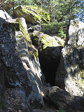
The summit of the Kreuzfelsen from the south |
||
| height | 998.5 m above sea level NHN | |
| location | District of Cham , Bavaria ( Germany ) | |
| Mountains | Bavarian forest | |
| Coordinates | 49 ° 10 '35 " N , 12 ° 55' 22" E | |
|
|
||
The Kreuzfelsen is 998.5 m above sea level. NHN high, protruding rock bar, which at the same time forms the western corner pillar of the elongated Kaitersberg . From its huge summit cross , the view goes down into the Zellertal and Bad Kötzting , but also far into the Upper Bavarian Forest .
Various hiking trails lead to the summit cross, the most popular of which is the E6 long-distance hiking trail , which leads from Kötzting via the nearby Kötztinger Hütte and the Großer Riedelstein to the Arber .
On the Kreuzfelsen there are also a number of worthwhile sport climbing routes that are well secured and can also be climbed in top rope .
Robber-Heigl Cave
Below the Kreuzfelsen is the Räuber-Heigl -Höhle, which served as a shelter for the robbers in the 19th century. The cave is designated as a geotope . It is a covering cave and was created by tearing apart mountains and falling blocks. The cave is well hidden about 50 m below the summit cross. A narrow entrance leads to a larger room, which narrows to a loophole at the back, which leads to the outside again. The various metamorphic structural elements of the gneiss can be seen particularly well on the rock walls in and around the cave.
Ascents
A selectable and probably shortest tour starts from the small town of “Arndorf”. From there, follow the trail markers "K3" and later "Bk3". In this way, the Kreuzfelsen can be reached in about one to one and a half hours. Despite its rather low altitude of 999 m, about 500 meters of altitude have to be overcome. There are also some steeper passages. Another possibility is to reach the summit from Riding Stone via Riding Mountain. Both routes start near Bad Kötzting and approach from the west.
Individual evidence
- ↑ Map services of the Federal Agency for Nature Conservation ( information )
- ↑ Geotope: Räuber-Heigl-Höhle SE von Reiterberg (accessed on November 3, 2015)
- ↑ Tour description from "Bergsteiger 1416 Outdoorblog" (accessed on May 6, 2016)


