Krummbach (Steinhauser Rottum)
| Krummbach | ||
|
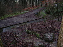
Krummbach in winter |
||
| Data | ||
| Water code | DE : 1137428 | |
| location | Biberach district | |
| River system | Danube | |
| Drain over | Steinhauser Rottum → Rottum → Westernach → Danube → Black Sea | |
| source | At Ochsenhausen 48 ° 3 ′ 21 ″ N , 9 ° 45 ′ 4 ″ E |
|
| Source height | 616 m above sea level NN | |
| muzzle | In Ochsenhausen in the lower Rottum coordinates: 48 ° 3 '57 " N , 9 ° 57' 20" O 48 ° 3 '57 " N , 9 ° 57' 20" O
|
|
| length | 2.3 km | |
| Catchment area | approx. 70 ha | |
The Krummbach is a creek artificially created by Benedictines in the 15th century, a so-called Klosterwaal , in Ochsenhausen in the district of Biberach in Baden-Württemberg .
geography
The Krummbach rises about one kilometer southwest of the Ochsenhausen monastery on a slope slightly inclined towards the valley of the Bellamonter Rottum (also called Obere Rottum ) and flows in a canal bed with a minimal incline to the northeast to the Ochsenhausen monastery. It is led under the monastery wall into the monastery complex and leaves it via a canal. In the area of the Ochsenhauser school center it comes to the surface again, is shown as a design element over its premises and then flows into the Steinhauser Rottum (also called Untere Rottum ).
history
The stream was the main piece of a technically highly developed canal system. Numerous connected watercourses and ponds provided water and energy for the monastery, the monastery brewery and the monastery mill. A water engineering history educational trail with information boards along the Krummbach tells the story of this historic water today.
Sights and buildings
- Ochsenhausen Monastery , former Benedictine - Reichsabtei
See also
Individual evidence
literature
- Lutz Dietrich Herbst: Water for the Ochsenhausen Monastery , Ochsenhausen 1993.


