Kuegrat
| Kuegrat | ||
|---|---|---|
|
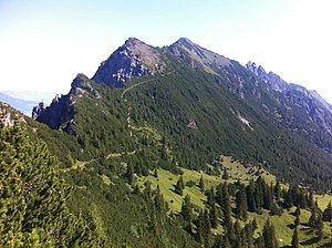
South-east side of the Kuegrat between Gafleispitze and Drei Schwestern (right) from the Gafleisattel |
||
| height | 2123 m above sea level M. | |
| location | Liechtenstein | |
| Mountains | Rätikon | |
| Dominance | 4.72 km → Galinakopf | |
| Notch height | 670 m ↓ Kulm | |
| Coordinates | 760 886 / 226 143 | |
|
|
||
|
Summit cross on the Kuegrat |
||
The Kuegrat (also called Kuhgrat ) is 2123 m above sea level. M. high mountain in the Principality of Liechtenstein . It is the highest peak in the three-sister chain , which lies in the extreme northwest of the Rätikon , a mountain group of the western central Alps .
location
The Kuegrat lies on the border of the Liechtenstein communities Schaan and Planken on the western edge of the Plankner Garselli southwest of the Garsellikopf (2105 m) and northeast of the Gafleispitze (1983 m). The summit cross was erected in 1983 by the rovers from Schaan.
Noteworthy peaks in the area (distance, direction)
- Garsellikopf 2105 m (514 m, 34 °)
- Three sisters 2052 m (1450 m, 46.7 °)
- Galinakopf 2198 m (4830 m, 108.8 °)
- Alpspitz 1997 m (2050 m, 193 °)
- Gafleispitze 1983 m (961 m, 206 °)
- Alvier 2343 m (12750 m, 238.8 °)
Ascent
The summit can be reached without any particular difficulties on hiking and mountain trails. Crossing the three sisters chain brings the most visitors to the Kuegrat summit.
- from Gaflei via Fürstensteig , Gafleisattel and Gafleispitze
- from Gaflei via Alp Bargälla , Chemmi, Gafleisattel and Gafleispitze
- from Planken to the Gafadurahütte and on via the Drei-Schwestern-Steig via the Drei Schwestern and the Garsellikopf
- from Schaan via the Alpila hut (rarely used)
Literature and map
- Braendle, Hermann: Rätikon Reader. Mountain hiking in the Rätikon. Bucher Verlag Hohenems Vienna, 2009, ISBN 978-3902679154 .
- Manfred Hunziker: Ringelspitz / Arosa / Rätikon , Alpine Tours / Bündner Alpen , Verlag des SAC 2010, ISBN 978-3-85902-313-0 , page 495
- Rudolf Mayerhofer: Alpine Club Guide Rätikon , Bergverlag Rother , Munich 2014, ISBN 978-37633-1098-2 , page 140
- National map of Switzerland 1: 25,000, sheet 1136, Three Sisters
Web links
Individual evidence
- ↑ Mountains and heights of Liechtenstein Liechtenstein Office for Statistics: Statistical Yearbook of Liechtenstein 2016 (PDF), p. 37, accessed on March 20, 2016


