
Kulm (Triesenberg)
| Kulm | |||
|---|---|---|---|
 Old tunnel (Ds old Tonäll) |
|||
| Compass direction | west | east | |
| Pass height | 1472 m above sea level M. | ||
| Alpine Rhine Valley ( Liechtenstein ) | Saminatal (Liechtenstein) | ||
| Watershed | Rhine | Samina → Ill → Rhine | |
| Valley locations | Triesenberg | Triesenberg footbridge | |
| Built | 1867 old tunnel (completed as a passable pass road) 1947 tunnel Gnalp – Steg |
||
| Mountains |
Rätikon Alpspitz (north) Chrüppel (south) |
||
| particularities | two tunnels with one-way control | ||
| profile | |||
| Ø pitch | % (546 m /? Km) | % (160 m /? Km) | |
| map | |||
|
|||
| Coordinates | 761 319 / 220464 | ||

The Kulm (from Alemannic Gulm or Rhaeto-Romanic cuolm (en) ) is a mountain crossing in the Rätikon in Liechtenstein . It lies in the area of the municipality of Triesenberg and connects the valley of the Alpine Rhine in the west with the Samina valley in the east. The pass is at an altitude of 1472 m . Since 1867 and 1947, two tunnels run through the mountain at 1430 and 1260 m.
According to documentary evidence, the entire mountain ridge from the Chrüppel (1707 m) in the south to the Alpspitz (1996 m) in the north was referred to as the Kulm; for example as Silumerkulm at Silum and Alpakulm at Alp Bargälla .
history
A path already led over the Kulm in the Late Bronze Age . In 1963, a bronze lance tip was found at an altitude of about 1470 m , which can be dated to the 12th or 11th century BC.
The Alps have been cultivated in Steg since the 14th century . A purchase letter from 1378 mentions the Gulmen for the first time . In 1615, farmers from the community of Triesenberg acquired Chleistäg (Klein-Steg) and in 1652 Grossstäg (Gross-Steg).
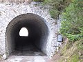
The farmers crossed the narrow and steep mule track, which often had to be kept free of snow, up to twice a day. The first gravel road between Vaduz and Malbun was laid in 1864 . At an altitude of 1430 m, “the” 48 m long “old tunnel” (colloquially Ds old Tonäll ) was driven through the Kulm in 1867 . The rotten, wooden reinforcement of the tunnel was replaced by masonry in 1899. The only passable road favored tourism . In 1908 and 1925 " Kurhäuser" were built in Malbun and on the Alpe Sücka .
The state parliament approved the funds for a new Gnalp – Steg tunnel in 1945. After seven months of construction, the breakthrough took place on September 4, 1946, and the inauguration on December 4, 1947. It is 740 m long and its portals are at 1253 m in the west and 1270 m in the east. The tunnel was renovated from 1989 to 1994. A referendum voted against the construction of a new, longer tunnel.
traffic
The modern tunnel is open all year round, for safety reasons in one-way traffic. The road to the old tunnel has been used as a natural toboggan run in winter since 1963.

West portal of the old tunnel
Old tunnel

New tunnel (2013)


Web links
- Herbert Hilbe: Kulm. In: Historical Lexicon of the Principality of Liechtenstein .
- Klaus Biedermann: Tunnel (Gnalp-Steg). In: Historical Lexicon of the Principality of Liechtenstein .
- Alois Ospelt: Bridge. In: Historical Lexicon of the Principality of Liechtenstein .
- Kulm (Triesenberg). In: Liechtensteiner Namenbuch ( Online ) 2005.
Individual evidence
- ^ Liechtenstein name book
- ↑ Ds as tone. Information signs on the tunnel portals. On Wikimedia Commons.