Mapungubwe cultural landscape
| Mapungubwe cultural landscape | |
|---|---|
|
UNESCO world heritage |
|

|
|
|
Mapungubwe Hill |
|
| National territory: |
|
| Type: | Culture |
| Criteria : | (ii), (iii), (iv), (v) |
| Surface: | 28,169 ha |
| Buffer zone: | 104,800 ha |
| Reference No .: | 1099bis |
| UNESCO region : | Africa |
| History of enrollment | |
| Enrollment: | 2003 (session 27) |
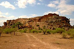
The Mapungubwe Cultural Landscape is a UNESCO - World Heritage Site near the northern border of South Africa to Zimbabwe and Botswana . It is an open, extensive savannah landscape at the confluence of the Limpopo and Shashe rivers . Mapungubwe developed into the largest kingdom on the subcontinent before it was abandoned in the 14th century. The remains of the palace complexes and the entire settlement area dependent on them as well as two former capitals, which together reflect the development of social and political structures over a period of over 400 years, have been preserved.
description
The Mapungubwe cultural landscape bears witness to the rise and fall of the first kingdom in southern Africa between AD 900 and 1,300. The core area of the World Heritage Site comprises almost 30,000 hectares and is supplemented by a buffer zone of around 100,000 hectares. The Mapungubwe National Park is located within the area .
Previously known Zhizo sites include the remains of three capitals - Schroda , Leopard's Kopje and the last one around Mapungubwe Hill - as well as their satellite settlements and fertile lands around the confluence of the Limpopo and Shashe, which have a large population within the kingdom nourished.
Mapungubwe's location at the junction of the north / south and east / west routes in southern Africa also enabled control of trade through the East African ports to India and China, as well as through all of southern Africa. Goods obtained from the hinterland , such as gold and ivory , which were scarce elsewhere, brought great wealth, which was demonstrated by imports such as Chinese porcelain and Persian glass beads .
Up until its demise at the end of the 13th century, Mapungubwe was the most important inland settlement of the African subcontinent and the cultural landscape contains a wealth of information in the form of archaeological sites that document its development. The findings show how trade grew and was increasingly influenced by a religiously led elite class.
Mapungubwe's downfall was brought about by climatic changes . During its last 2000 years, phases of warmer and wetter climates suitable for agriculture in the Limpopo / Shashe Valley were interspersed with cooler and drier interruptions. When rainfall decreased after AD 1300, the land could no longer support a large population using traditional farming methods, and residents were forced to disperse. Mapungubwe's position as a power base shifted north to Greater Zimbabwe and later to Khami .
Registration as a world heritage site
The cultural landscape of Mapungubwe was entered into the list of UNESCO World Heritage Sites in South Africa in 2003 based on a resolution of the 27th session of the World Heritage Committee.
The World Heritage Site covers an area of 28,169 hectares with a buffer zone of 104,800 hectares, which was established in 2014.
The reason for the entry states, among other things:
The remnants of this important kingdom, together with today's flora and fauna and the geomorphological formations of the Limpopo / Shashe confluence, form an impressive cultural landscape of universal importance.
The entry was made on the basis of criteria (ii), (iii), (iv) and (v).
(ii): The Mapungubwe cultural landscape contains clues for an important exchange of human values that led to far-reaching cultural and social changes in southern Africa between AD 900 and AD 1300.
(iii): The remains in the Mapungubwe Cultural Landscape are a remarkably complete testimony to the growth and subsequent decline of the Mapungubwe State, which at its height was the largest kingdom on the African subcontinent.
(iv): The establishment of Mapungubwe as a powerful state that traded with Arabia and India via the East African ports was a significant stage in the history of the African subcontinent.
(v): The remains in the cultural landscape of Mapungubwe illustrate the effects of climate change and document the growth and then the decline of the Kingdom of Mapungubwe. They clearly demonstrate a culture that has become prone to irreversible change.
Web links
Individual evidence
- ↑ a b c d e f g h i Entry on the website of the UNESCO World Heritage Center ( English and French ).
- ↑ Decision: 27 COM 8C.30 - Mapungubwe Cultural Landscape (South Africa). UNESCO World Heritage Center, 2000, accessed August 5, 2020 .
Coordinates: 22 ° 11 ′ 33 ″ S , 29 ° 14 ′ 20.4 ″ E
