Cumeu
| Cumeu | ||
| Geographical location | ||
|
|
||
| Coordinates | 36 ° 47 ′ S , 174 ° 33 ′ E | |
| Region ISO | NZ-AUK | |
| Country |
|
|
| region | Auckland | |
| District | Auckland Council | |
| Ward | Rodney Ward | |
| Residents | 1 449 (2013) | |
| height | 23 m | |
| Post Code | 0810 | |
| Telephone code | +64 (0) 9 | |
| UN / LOCODE | NZ KUE | |
| website | www.kumeudistrict.co.nz | |
| Photography of the place | ||
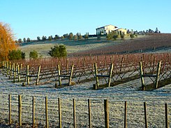
 Viticulture in Kumeu |
||
| Remarks | ||
| belonged to the Rodney District until October 2010 | ||
Kumeu is a small town in the Auckland Council metropolitan areaon the North Island of New Zealand . Until the end of October 2010, the city belongs to the former Rodney District , which wassubordinated to the Auckland Councilas Rodney Ward as part of an administrative reorganization from November 1, 2010.
Origin of name
The name Kumeu comes from the Māori language and is composed of kume for draw and u for bosom or breast. The women of a tribe are said to have exposed themselves and pulled their breasts in order to incite their warriors to a campaign of revenge.
geography
Kumeu is located approximately 20 km northwest of downtown Auckland . The small town of Huapai borders directly to the northwest of the city and the small town of Riverhead is 3.5 km northeast .
history
The area was originally settled by immigrants from Dalmatia on the Croatian coast, often from wine-growing families.
population
At the 2013 census, the city had 1,449 inhabitants, divided into 474 households.
economy
Kumeu calls itself " The Fruit Bowl of Auckland " ("The fruit bowl of Auckland"). In the area around Kumeu , fruit is grown as well as wine, especially the Chardonnay and Sauvignon Blanc varieties . Notable wineries in the area include Kumeu River Wines (founded 1944), Coopers Creek (1980) and Matua Valley . The Nobilos winery was founded by Nikola Nobilo in 1943 and remained family-owned until the late 1990s. Today's Nobilo Wine Group is New Zealand's second largest wine producer.
Infrastructure
Road traffic
The New Zealand State Highway 16 runs directly through the city, connecting it to the various districts of Auckland in the southeast and Helensville in the northwest.
Rail transport
The North Auckland Line also runs through the city. For six years, Kumeu was the endpoint of the isolated Kumeu - Riverhead Section . This railway line connected Kumeu with Riverhead , from where ferries ran to Auckland . This line was operated from 1875 to 1881. The North Auckland Line was later built and the route to Riverhead was dismantled.
In June 2007 it was announced that 2008 the Auckländer suburban traffic to Helensville will be expanded. Temporary stations should be built in Huapai and Waimauku . The connection was put into operation on July 14, 2008 for a one-year trial phase.
Education
The only school in Kumeu itself is the primary school " Hare Krishna School ", integrated into the state education system, with 84 students in 2010 and a decile rating of 5. In addition, in the Huapai District School belonging to Kumeu , there is a primary school with 390 students in 2010 and a decile rating of 9.
Higher education students attend schools in the surrounding towns and suburbs, including Massey High School , Liston College , Albany Junior High School , Kaipara College, and St Dominic's College . Some students also commute to Marist College and St Peter's College in Auckland .
literature
- Helga Neubauer: Kumeu . In: The New Zealand Book . 1st edition. NZ Visitor Publications , Nelson 2003, ISBN 1-877339-00-8 , pp. 192 .
Web links
- Kumeu & Districts . Retrieved July 3, 2017.
Individual evidence
- ↑ a b 2013 Census QuickStats about a place: Rodney Local Board Area . Statistics New Zealand , accessed on July 3, 2017 (English, StatsMap: Kumeu East - Meshblock evaluation from the interactive map).
- ^ Neubauer: Kumeu . In: The New Zealand Book . 2003, p. 192 .
- ↑ Topo250 maps . Land Information New Zealand , accessed July 3, 2017 .
- ^ Kumeu River History . Archived from the original on September 29, 2007 ; accessed on August 25, 2014 (English, original website no longer available).
- ^ History . Coopers Creek , archived from the original on April 20, 2010 ; accessed on August 25, 2014 (English, original website no longer available).
- ^ Commuter train services to resume to Helensville . In: New Zealand Herald . NZME. Publishing , June 27, 2007, accessed April 24, 2019 .
- ↑ a b School database of the Ministry of Education (accessed December 31, 2010)

