Kunja (Lowat)
|
Kunja Ку́нья |
||
|
Confluence of the Kunja (left) into the Lowat |
||
| Data | ||
| Water code | RU : 01040200312102000023209 | |
| location | Oblasts Pskov , Tver , Novgorod ( Russia ) | |
| River system | Neva | |
| Drain over | Lowat → Volkhov → Neva → Baltic Sea | |
| origin | See Wstesselewo 56 ° 9 '26 " N , 30 ° 59' 3" O |
|
| Source height | 168 m | |
| muzzle | near Cholm in the Lowat coordinates: 57 ° 8 '48 " N , 31 ° 9' 58" E 57 ° 8 '48 " N , 31 ° 9' 58" E |
|
| Mouth height | 46 m | |
| Height difference | 122 m | |
| Bottom slope | 0.52 ‰ | |
| length | 236 km | |
| Catchment area | 5143 km² | |
| Outflow at the level at the mouth |
MQ |
44.8 m³ / s |
| Right tributaries | Seryosha | |
|
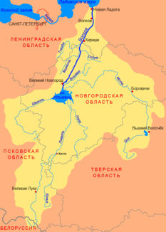
Location of the Kunja (Ку́нья) in the catchment area of the Volkhov |
||
The Kunja ( Russian Ку́нья ) is a right tributary of the Lowat in the Russian oblasts of Pskov , Tver and Novgorod .
The Kunja has its origin in the small lake Wstesselewo in the Pskov Oblast. It flows mainly in a northerly direction. It crosses part of the Tver Oblast. Finally, it opens in the Novgorod Oblast in the small town of Chelm in the Lovat.
The Kunja has a length of 236 km. It drains an area of 5143 km². It is mainly fed by the snowmelt . The mean discharge at the mouth is 44.8 m³ / s. At the beginning of December the kunja freezes. At the end of March it will be free of ice again.
The most important tributary, the Serjoscha , flows into the Kunja from the right at river kilometer 33.

