Cycladic Arch
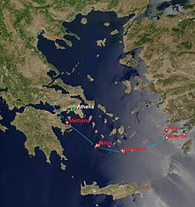
The Cycladic Arch is a volcanic island arch in the southern Aegean Sea . It is approx. 450 km long and 20 to 40 km wide and runs from the Isthmus of Corinth to the Bodrum Peninsula in Asia Minor . On this arch lie the Greek volcanic islands Aegina , Methana (peninsula), Milos , Santorin , Nisyros , Gyali , Kos and Poros as well as the underwater volcano Columbos and the small, uninhabited Christiana Islands , and the volcanoes Sousaki in the isthmus of Corinth and Akyarlar on the Bodrum Peninsula.
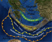
In a zone south of Crete ( deep sea trench ), the African plate is currently pushing 5 cm per year under the Aegean plate , a sub-plate of the Eurasian plate . At depths of around 150 to 180 km, the mantle rock above the slab is melted by volatile components ( carbon dioxide , crystal lattice water , halogens ) escaping from it . These gases then dissolved in the melt lift the molten rock and rise again to the surface of the earth in the form of volcanoes in an arcuate zone approx. 120 km north of Crete (volcanic products: andesites , dazites , rhyolites ).
literature
- Volker Jacobshagen , Geology of Greece (1986).
Individual evidence
- ↑ Akyarlar ( English ) Volcanodiscovery.com. Retrieved March 29, 2020.
- ↑ David M. Pyle, John R. Elliott: Quantitative morphology, recent evolution, and future activity of the Kameni islands volcano, Santorini, Greece . In: Geosphere . tape 36 , no. 2 , 2006, p. 253-268 .
Coordinates: 36 ° 25 ' N , 25 ° 26' E

