
Milos
|
Milos municipality Δήμος Μήλου (Μήλος) |
|||
|---|---|---|---|
|
|||
| Basic data | |||
| State : |
|
||
| Region : | South Aegean | ||
| Regional District : | Milos | ||
| Geographic coordinates : | 36 ° 41 ′ N , 24 ° 25 ′ E | ||
| Area : | 160.147 | ||
| Residents : | 4,977 (2011) | ||
| Population density : | |||
| Community logo: |
|
||
| Seat: | Milos | ||
| LAU-1 code no .: | 6501 | ||
| Districts : | no | ||
| Local self-government : |
2 city districts 3 local communities |
||
| Website: | www.milos.gr | ||
| Location in the South Aegean region | |||
 |
|||

Milos ( modern Greek Μήλος ( f. Sg. )), Also Melos (from ancient Greek Μῆλος Mēlos ), is a Greek island in the Aegean Sea . Together with Andimilos , some smaller, uninhabited islands and the Ananes group of islands about 23 km to the southwest, the Cyclades island forms a municipality (δήμος, Dimos ) within the South Aegean region (Περιφέρεια Νότιου Αιγαίου).
With an area of around 160.147 square kilometers and almost 5000 inhabitants (2011), Milos is comparatively densely populated. The main town of the same name is located above the port of Adamas . Other places on the island are Tripiti , Triovasalos and Apollonia . There is a daily ferry from Apollonia to the small neighboring island of Kimolos .
A specialty of Milos are the Syrmata , houses built directly on the waterline, the ground floor of which serves as a safe shelter for fishing boats in winter. With their colorful 'garage doors' they offer a unique sight, especially when the Syrmata line the coast, grouped together to form small villages like Klima or Mandrakia.
Milos is the place where Venus de Milo was found , correctly known in Greece as Aphrodite de Milos. The original is on display in Paris in the Louvre . A copy can be seen in the Archaeological Museum of Milos.
geography
The island almost completely encloses an extensive bay on which the few port villages are located. The highest point is the Profitis Ilias in the west of the island , at 748 meters . The rocky coast around the flatter eastern part of the island is lined with a few beaches, which are particularly noticeable for their multi-colored rocks and sands.
About 20 kilometers northwest of Milos lies the uninhabited island of Andimilos .
Community structure
The municipality of Milos is divided into two districts and three local communities with 37 villages, settlements and islands
| District local community |
Greek name | code | Area (km²) | 2001 residents | Residents 2011 | Villages and islands |
|---|---|---|---|---|---|---|
| Milos | Τοπική Κοινότητα Μήλου | 65010001 | 89.505 | 919 | 819 | Milos, Akanthi, Ananes , Andimilos , Areti, Embourios, Kipos, Xylokeratia, Paximadia, Provatas, Palaki Chalakos, Fourkovouni, Fyropotamos, Psathadika |
| Adamas | Δημοτική Κοινότητα Αδάμαντος | 65010002 | 3.749 | 1391 | 1347 | Adamas |
| Triovasalos | Δημοτική Κοινότητα Τριοβασάλου | 65010003 | 18,388 | 1029 | 1240 | Triovasalos, Agii Anargyri, Agios Gerasimos, Apollonia , Voudia, Glaronisia, Kaminia, Mandrakia, Mytikas, Pachena, Pilonisi, Fylakopi |
| Pera Triovasalos | Τοπική Κοινότητα Πέραν Τριοβασάλου | 65010004 | 13.612 | 644 | 698 | Pera Triovasalos, Katsaronas, Komia |
| Trypiti | Τοπική Κοινότητα Τρυπητής | 65010005 | 34.893 | 788 | 873 | Trypiti, Agia Kyriaki, Zefyria, Kanava, Klima, Paliochori, Schinopi |
| total | 6501 | 160.147 | 4771 | 4977 | ||
geology
The island of Milos belongs to the volcanic islands of the Aegean island arc ( Methana , Santorin and Nisyros ). It is formed by an old stratovolcano , which is littered with younger lava domes , pyroclastic cones and tuff rings .
Even if the last volcanic eruption was around 60,000 years ago ( Tsingrado volcano ), there are still signs of strong magmatic activity underground. A magma chamber at a depth of about 6–8 km continues to provide strong hydrothermal activity. As a result, there are hot springs (up to about 80 ° C) and fumaroles up to about 98 ° C (hot outlets of water vapor and sulfur gases) in numerous places on the island . There were also phreatic outbreaks . 140 nC spilled by a thin layer of ash subordinate Lahar nor Roman walls. Most of the island has been chemically altered significantly by hot solutions. This led to the formation of various deposits. Were enriched bentonite , perlite , baryta , zeolite , manganese , kaolin , sulfur , pozzolan and larger occurrence mineable gold in the vicinity of the Profiti-Ilias summit. Due to the resistance of the local population against gold mining because of its particular environmental hazard, the planned gold mining was not started.
Volcanism also led to the island's most important product: Melian obsidian has been used since the end of the Paleolithic , as is shown by finds from the Franchthi cave, for example . Since the early Neolithic (Proto-Sesklo) it has been found in the entire eastern Aegean. Obsidian is an important raw material for the manufacture of weapons and tools. It has been mined on a large scale on Milos since the Bronze Age.
Striking volcanoes on Milos
- Tsingrado volcano and a surrounding field of over twenty phreatic craters
- Milos Bay (two or three former volcanic craters)
- Profitis Ilias summit (noticeable volcanic dome)
- Volcanoes in the northeast of the island that are slowly being eroded by mines
Thermal springs and hot gas leaks
- hot springs in the sea at the Adamas power station
- former geothermal power plant near Zefyria, which has since been blown up
- Sulfur mine near Zefyria
- Thermal springs and fumaroles at Paliochori and Agia Paraskevi
- Kalamos fumaroles
history
Finds show that Milos has been around since 5000 BC. Permanently inhabited. From the early Bronze Age around 2500 BC. There are settlement finds that can be assigned to the Keros-Syros culture . Since the end of the early Cycladic period around 2000 BC BC Phylakopi was one of the first urban settlements on Melos, which, along with Agia Irini on Kea and later Akrotiri on Santorini, was one of the most progressive cities in the Mediterranean. It also existed in Mycenaean times until around 1100 BC. Chr. Further. At that time Melos was a center of trade in ceramics and obsidian , the material for most of the tools of the time.
During the Peloponnesian War in the 5th century BC BC the inhabitants of Melos opposed the mighty Athens. After the Athenians had enclosed the eponymous capital of the island with a siege wall, the city ran out of supplies and had to surrender for better or for worse. As a result, all the male residents were executed and the women and children enslaved. The Athenian politician and historian Thucydides describes this incident in the Melierdialog in Book V, Chap. 84–116 of his work on the Peloponnesian War .
gallery
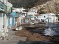
The fishermen's summer settlement Klima with the typical syrmata , a mixture of house and ship's garage
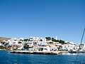
Adamas

Bougainvillea in Milos - Plaka

Milos - Paleochori

Inscription on tomb in the catacombs of Milos

Milos Sarakiniko


economy
Milos is one of the few Greek islands where more people work in mining and related industries than in the tourism sector. Are degraded bentonite , perlite , pozzolan , quartz-rich rocks, clay and small amounts of barite . Near the small airport, the remains of salt pans ( Greek Αλυκές ) including the loading station can still be seen, which were used for salt production until the 1980s.
Despite the healthy mining industry, lucrative tourism is also becoming more and more important on Milos. Above all, the island is developing into a resort for high-earning Athenians and northern Greeks who travel to Milos thanks to the good connections. The proportion of foreign property owners is also growing steadily and contributing to the island's image change.
In 2008, a wind-powered salt water desalination plant was put into operation. This is driven by a 600 kW wind turbine, the drinking water tank has a capacity of 3,000 m³. The system replaces the supply by tanker.
traffic
In addition to the air route, Milos can also be easily reached by ship. There are one to two ferry connections per day from Piraeus , travel time around 5–7 hours, including the ferry Piraeus-Milos-Crete-Karpathos-Rhodes several times a week, and one or two high-speed ferry connections from Piraeus (AegeanSpeedLines / Seajets), travel time around 3 -4 hours. In addition, ferries and fast ferries to other Cycladic islands operate several times a week. However, the timetable is severely restricted in winter.
Milos airport
Milos Airport ( IATA : MLO , ICAO : LGML ) is located 9 kilometers southeast of the port city of Adamas and was opened on January 17, 1973. The asphalt runway with an orientation of 08/26 is 1,030 m long. The airport is 3 m (10 ft) above sea level . At the small airport start twice daily 36-seater De Havilland DHC-8-100 of Olympic Airlines to Athens , even Sky Express offers flights to Athens. International airlines do not fly to the airport.
![]()
Island partnership
Milos Island has had an island partnership with Shōdoshima , Japan , since October 8, 1989 .
literature
- Colin Renfrew, Malcolm Wagstaff (eds.): An Island polity: the archeology of exploitation in Melos . Cambridge University Press, Cambridge 1982.
- R. Torrence: Monopoly or direct access? Industrial organization at the Melos obsidian quarries . In: B. Purdy, JE Ericson (Eds.): Quarry Production Analysis . Cambridge 1984, p. 49-63 .
- R. Torrence: Obsidian extraction and processing on the Greek island of Melos. A contribution to barter . In: The cut . tape 3 , 1981, p. 86-103 .
- R. Torrence: Macrocore production at the Melos obsidian quarries . In: Lithic Technology . tape 8 , 1979, pp. 51-60 .
- I. Palmer: Milos - Geological history . KOAN, ISBN 960-7586-43-3 .
Web links
- Official website of the municipality of Milos (English and Greek)
- Milos in the Global Volcanism Program of the Smithsonian Institution (English)
Individual evidence
- ↑ Results of the 2011 census, Greek Statistical Office (ΕΛ.ΣΤΑΤ) ( Memento from June 27, 2015 in the Internet Archive ) (Excel document, 2.6 MB)
- ↑ Ελληνική Στατιστική Αρχή [ΕΛΣΤΑΤ] (Ed.): Στατιστική Επετηρίδα της Ελλάδος (Statistical Yearbook of Greece) 2009 & 2010 . Piraeus 2011, p. 47 .
- ^ [1] From Global Volcanism Program, Smithsonian Institution at [2]
- ↑ Thucydides: The Melierdialog (17th chapter). In: The History of the Peloponnesian War. Retrieved November 1, 2015 .
- ↑ Desalination from wind in Milos Island. (PDF; 20 kB) Ios Aegean Energy Agency, accessed on January 20, 2013 .
- ↑ Milos Airport. In: airportguide.com. Accessed February 2, 2020 .
- ↑ Αδερφοποιήσεις πόλεων Ελλάδας-Ιαπωνίας greecejapan.com, September 25, 2012