Evdilos
|
Evdilos parish Δημοτική Ενότητα Ευδήλου (Ευδήλος) |
||
|---|---|---|
|
|
||
| Basic data | ||
| State : |
|
|
| Region : |
North Aegean
|
|
| Regional District : | Ikaria | |
| Municipality : | Ikaria | |
| Geographic coordinates : | 37 ° 38 ′ N , 26 ° 11 ′ E | |
| Height above d. M .: | 0 - 1037 m Aegean Sea - Efanos |
|
| Area : | 78.790 km² | |
| Residents : | 2,749 (2011) | |
| Population density : | 34.9 inhabitants / km² | |
| Code No .: | 540102 | |
| Structure: | 6 local communities | |
| Located in the municipality of Ikaria and in the Ikaria regional unit | ||
The port of Evdilos (Ευδήλος ( m. Sg. )) With 501 inhabitants (2011), together with the local communities Arethousa , Dafni , Karavastamo , Manganitis and Frandato, has been the eponymous district of Evdilos on the Greek island of Ikaria since 2011 . Recognized as a rural community (kinotita) in 1918 , it was enlarged over time through incorporations and was last established in 1997 through a merger with five other rural communities as the municipality of Evdilos (Dimos Evdilou) in the prefecture of Samos . With the administrative reform in 2010 , this municipality became the municipality of Evdilos in the newly created municipality of Ikaria, which encompasses the entire island and has since formed one of three municipal districts.
location
The area rises from the north coast to the main ridge of the Atheras Mountains , which run through the island along its entire length from northeast to southwest. The border to the municipality of Agios Kirykos in the east runs over a length of about 7 km in the immediate vicinity of the main ridge with the highest elevation on the island, the 1037 m high Efanos (Εφανός). To the south the terrain drops steeply into the sea. The parish of Raches lies to the west.
structure
The municipality is divided into six local communities with numerous settlements. The population figures are from the 2011 census.
| Local community | Greek name | code | Area (km²) | 2001 residents | Residents 2011 | Villages and settlements |
|---|---|---|---|---|---|---|
| Evdilos | Τοπική Κοινότητα Ευδήλου | 54010201 | 8.376 | 726 | 768 | Evdilos, Agia Kyriaki, Dekakia, Droutsoulas, Kerami, Kyparissi, Xanthi, Fytema |
| Arethousa | Τοπική Κοινότητα Αρεθούσης | 54010202 | 9,851 | 187 | 178 | Arethousa, Kyparissi Arethousis, Pera Arethousa, Finikas |
| Dafni | Τοπική Κοινότητα Δάφνης | 54010203 | 19.829 | 520 | 516 | Dafni, Akamatra, Kosikia, Petropouli, Plagia, Platani, Steli |
| Karavostamo | Τοπική Κοινότητα Καραβοστάμου | 54010204 | 8,454 | 524 | 499 | Karavostamo |
| Manganitis | Τοπική Κοινότητα Μαγγανίτου | 54010205 | 14.802 | 216 | 108 | Manganitis, Kalamonari |
| Frandates | Τοπική Κοινότητα Φραντάτου | 54010206 | 17,478 | 658 | 608 | Frandates, Avlaki, Kalamourida, Kambos, Kremasti, Maratho, Pigi, Stavlos |
| total | 540102 | 78.790 | 2831 | 2749 | ||
- Evdilos
Evdilos (Ευδήλος ( m. Sg. )) Is located on the north coast about 40 km northwest of Agios Kirykos. The place was founded after 1830. During the second Ottoman occupation, Evdilos was the island's capital from 1834 to 1912.
- Arethousa
Arethousa (Αρέθουσα ( f. Sg. )) Lies on a ridge at a height of 300 m and borders Evdilos to the east
- Dafni
Dafni (Δάφνη ( f. Sg. )) Is located south of Evdilos. The associated settlements are in the immediate vicinity of the only road that leads in the central island area to the south side of the island.
- Karavastamo
Karavastamo (Καραβόσταμο ( n. Sg. )) Is located in the northeast on the border with the municipality of Agios Kirykos.
- Manganitis
Manganitis (Μαγγανίτης ( m. Sg. )) Is on the south side of the island.
- Frandato
Frandato (Φραντάτο ( n. Sg. )) Is located west of Evdilos and borders on the municipality of Raches .
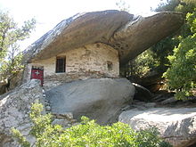
- Pigi near the village is the monastery of Theoktistis (Μονή Θεοκτίστης). It is named after a nun of the same name from Lesbos. The monastery was founded in Byzantine times. The first church was built under rocks around 1300 AD. During the heyday, at the end of the 15th century, the monastery was inhabited by around 100 monks. The monastery has been abandoned since 1982.
- Kambos (Κάμπος ( m. Sg. )), In the area of the village is the ancient city of Ini (Οινόη), which was the capital of the island from ancient times to Byzantine times. The ancient port that was at the mouth of the Voutside River was silted up by alluvial material from the river and is now off the sea. Ruins of the city wall, the stadium and some buildings are still visible from the city. Wine production brought wealth to the place, which is why contributions were paid into the federal treasury of the Attic League . The Kambos Museum is located next to the Agia Irini Church, which was built on the ruins of an ancient Dionysus temple. In addition to finds from antiquity, the museum also houses tools from the Neolithic Age.
Web links
- General information nikaria.gr (Greek)
Individual evidence
- ^ Map 209, Ikaria / Fourni, 1: 50,000 . Road Editions, ISBN 960-8189-48-9 .
- ^ Map NA 6, Samos - Ikaria, 1: 70,000 . Z-Editions, ISBN 960-6693-12-0 .
- ↑ a b Results of the 2011 census, Greek Statistical Office (ΕΛ.ΣΤΑΤ) ( Memento from June 27, 2015 in the Internet Archive ) (Excel document, 2.6 MB)


