
Kyrenia Mountains
| Kyrenia Mountains | ||
|---|---|---|
| Highest peak | Selvili Tepe ( 1024 m ) | |
| location | Turkish Republic of Northern Cyprus | |
|
||
| Coordinates | 35 ° 17 ' N , 33 ° 32' E | |
| rock | limestone | |

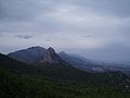
The Kyrenia Mountains , Greek Βουνά της Κερύνειας Vouná tis Kerýneias , Turkish Girne Dağları , also Kyrenia Mountains (after one of the ancient names of today's city of Girne ), is a mountain range in the north of the Mediterranean island of Cyprus in the Turkish Republic of Northern Cyprus . After the striking pentadactylos , the entire mountain range is sometimes referred to by this name in the literature.
The mountains are made of limestone and fall relatively steeply into the sea in the north. It consists of sediments deposited between the Permian and Middle Miocene and made perpendicular by the collision of the African and Eurasian plates . The highest mountain is the Kyparissovouno (Selvili Tepe) at 1024 m .
The Kyrenia Mountains run northeast in the narrow Karpas peninsula and in the west at Cape Kormakitis .
Several castles belonging to the French aristocratic family of the Lusignans and monasteries from the Byzantine and Franconian times use the rugged location and the wide view from 1200, including the castles of St. Hilarion , Buffavento and Kantara as well as the Gothic Abbey of Bellapais of the Premonstratensian order .
In 1974/75 fires triggered by air raids destroyed large areas of the forest in the Kyrenia Mountains. In 1995 another major forest fire, presumably triggered by speculation, destroyed almost 6,500 hectares of forest around Girne. The forests have not yet recovered from this and the reforestation is only very slow due to the dry climate.
The Kyrenia Mountains

The Pentadaktylos / Beşparmaklar

The port of Kyrenia (Girne) with the mountains in the background


Web links
- Gustav Hiessleitner: Contribution to the geology of Cyprus . (PDF; 1.36 MB) 1955
- cypnet.co.uk (English)