Lachlan River (Murrumbidgee River)
| Lachlan River | ||
|
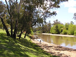
The Lachlan River at Cowra |
||
| Data | ||
| location | New South Wales , Australia | |
| River system | Murray River | |
| Drain over | Murrumbidgee River → Murray River → Indian Ocean | |
| source | at Gunning, west of Goulburn 34 ° 46 ′ 6 ″ S , 149 ° 26 ′ 25 ″ E |
|
| Source height | 699 m | |
| muzzle |
Murrumbidgee River at Oxley Coordinates: 34 ° 21 ′ 17 " S , 143 ° 56 ′ 58" E 34 ° 21 ′ 17 " S , 143 ° 56 ′ 58" E |
|
| Mouth height | 67.6 m | |
| Height difference | 631.4 m | |
| Bottom slope | 0.44 ‰ | |
| length | 1440 km | |
| Catchment area | 84,700 km² | |
| Drain |
MQ |
40 m³ / s |
| Left tributaries | Blakney Creek, Bramah Creek, Boorowa River , Hovells Creek, Neila Creek, Morongla Creek, Crowther Creek, Pipe Clay Creek, Kangarooby Creek, Ulguthrie Creek, Island Creek, Wallaroi Creek, Box Creek, Cabbage Garden Creek, Gums Creek, Yandumblin Creek, Mirool Creek, Pimpara Creek | |
| Right tributaries | Humes Creek, Crookwell River , Mulgowie Creek, Abercrombie River , Milburn Creek, Waugoola Creek, Belubula River , Mandagery Creek, Bumbuggan Creek, Geobang Creek, Kiagathur Creek, Borapine Creek, Booberoi Creek, Mountain Creek, Willandra Creek, Middle Creek, Merrowie Creek , Torriganny Creek, Merrimajeel Creek | |
| Reservoirs flowed through | Lake Wyangala | |
| Medium-sized cities | Cowra , Forbes , Lake Cargelligo, Hillston | |
| Small towns | Reids Flat, Wyangala, Gooloogong, Waroo, Gunebang, Euabalong, Murrin Bridge, Wheelbah, Oxley | |
The Lachlan River , named after Lachlan Macquarie , is a 1,440 km long river in the Australian state of New South Wales .
It rises 13 km east of Gunning in the highlands of New South Wales, a southern branch of the Great Dividing Range . Its main headwaters are the Belubula and Abercrombie Rivers , which flow near Cowra , and the Morongla Creek.
The Lake Wyangala at Cowra was built to regulate the water flow of the Lachlan River. Since the Lachlan River does not have its source in the winter snowfields of the Australian Alps like the Murray River and Murrumbidgee River , which rises further south , and thus the spring melt does not occur, it has an irregular watercourse. The annual runoff ranges from 1 million m³ in 1944 to 10,900 million m³ in 1950. In periods of drought, it cannot carry any water all year round, for example from April 1944 to April 1945, this has never been observed with the Murray River and Murrumbidgee River since European settlement .
See also
Web links
Individual evidence
- ↑ a b c Map of Lachlan River, NSW . Bonzle.com
- ^ Johann Jakob Egli : Nomina geographica. Language and factual explanation of 42,000 geographical names of all regions of the world. , Friedrich Brandstetter, 2nd edition Leipzig 1893, p. 520
