
Lake Ghirla
| Lake Ghirla | ||
|---|---|---|

|
||
| Geographical location | Varese Province , Lombardy , Italy | |
| Tributaries | Margorabbia | |
| Drain | Margorabbia | |
| Places on the shore | Ghirla | |
| Data | ||
| Coordinates | 45 ° 54 '59 " N , 8 ° 49' 22" E | |
|
||
| Altitude above sea level | 442 m slm | |
| surface | 28.3 ha | |
| length | 1.29 km | |
| width | 380 m | |
| scope | 3.12 km | |
| Maximum depth | 14 m | |

The Lago di Ghirla is a lake in the municipality of Valganna in the Lombardy .
geography
The lake is located between the large Swiss-northern Italian lakes Lago Maggiore and Lago di Lugano , in the triangle of the cities of Luino , Varese and Lugano ( Ticino , Switzerland ). It is nestled in a densely wooded pre-Alpine landscape at the foot of Monte Piambello (1129 m above sea level). Together with the much smaller Lago di Gamma , it belongs to the Margorabbia river system . The district of Ghirla is located directly on the shore of the lake. On the opposite shore of the lake is the 3 Lago campsite with an extensive lawn for sunbathing. High above the eastern steep bank lies at 736 m above sea level. M. the mountain village of Boarezzo.
gallery

Looking north, 2007
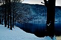
Winter on Lake Ghirla, 2008
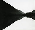
Photo by the art photographer Paolo Monti , 1955


_-_BEIC_6346773.jpg)