Lajamanu
| Lajamanu | |||||||
|---|---|---|---|---|---|---|---|
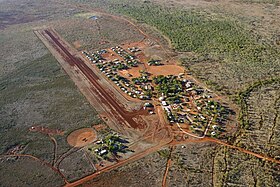
 Aerial view of Lajamanu and its runway. |
|||||||
|
|||||||
|
|||||||
|
|||||||
|
|||||||
|
|||||||
|
|
|||||||
[[Category: Location in Northern Territory ]]
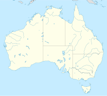
Lajamanu (formerly Hooker Creek ) is a small town in the northwest of the Northern Territory in Australia . It is located on the northern corner of Warlpiri Aboriginal Land in the foothills of the Tanami Desert , 557 kilometers southwest of Katherine (464 kilometers as the crow flies) and 872 kilometers south of Darwin (653 kilometers as the crow flies). The 2016 census showed 656 inhabitants, 89.1% of whom are Aborigines .
history
The area where Lajamanu is located today has been inhabited by the Gurindji Aboriginal tribe for more than 40,000 years . However, the Gurindji were relocated through projects by the Australian government. Later - more or less by chance - Warlpiri aborigines were settled.
In the middle of the 20th century Warlpiri lived in Yuendumu . In 1948 the decision Native Affairs Branch (about Department of Native Affairs ) of the Australian Federal Government, it due to drought and overcrowding fears of Catfish , a permanent waterhole nearly 600 kilometers north of Yuendumu to relocate. The road builder who was to use a grader to create the road to this new settlement was guided towards the Catfish by two Warlpiri men. However, 150 kilometers from their destination, they lost their bearings and turned back. Nevertheless, 25 Warlpiri were sent in a motorized transport towards Catfish. On their way there they camped at Hooker Creek - and since it even had water, they decided to stay there instead of traveling on to Catfish.
Over the next few years, 550 more Warlpiri were transported from Yuendumu to Hooker Creek. However, they were so unhappy with the separation from their relatives and their ancestral land that they walked back to Yuendumu. Even after being transported to Hooker Creek again, they migrated back to their original place of residence. Only after the third transport did they stay and accept Hooker Creek at the northern end of the Tanami Desert as their new home, even if their spiritual roots remained in the southern Tanami Desert.
In the 1970s, the Lajamanu Council became the Northern Territory's first Community Government Council . In 2008 he became part of the Central Desert Shire Council .
climate
In this part of the Northern Territory there is a dry and a rainy season: More than 80 percent of the annual precipitation falls from December to March, during the remaining months it only rains very sporadically. In the summer months from September to April it gets very hot, with daily maximum temperatures of well over 30 degrees Celsius. Although the heat cools down a bit overnight, it remains quite warm (18 to 24 degrees Celsius daily low temperature). The winter, especially June / July, is much colder, but this time with more moderate temperatures between 9 and around 30 degrees Celsius is still very mild.
The lowest temperature ever recorded was −0.1 ° C on June 27, 1971, the highest 45.4 ° C on December 8, 2009. With 171 mm, the highest daily precipitation was recorded on January 30, 2006.
|
Average monthly temperatures and rainfall for Lajamanu
Source: Australian Bureau of Meteorology : LAJAMANU Station. Observation periods: temperatures 1967–2013, rain amounts / days 1952–2013.
|
||||||||||||||||||||||||||||||||||||||||||||||||||||||||||||||||||||||||||||||||||||||||||||||||||||||||||||||||||||||||||||||||||||||||||||||||||||||||||||||||||||||||||||||||||||
language
The majority of the population speaks Warlpiri . The place became widely known in 2013 when linguist Carmen O'Shanessy described the emergence of a new language, Light warlpiri .
traffic
Due to its remote location far from larger cities, Lajamanu is relatively difficult to reach. Road access is via a 110-kilometer gravel road that leads to the Buntine Highway . After 323 kilometers this joins the Victoria Highway , which as part of National Highway 1 represents the further connection to Katherine and Darwin (via Stuart Highway ) or to Western Australia .
With the Hooker Creek Airport Lajamanu has a 1560 meter long gravel runway. The flight time is an hour or two from Katherine and two and a half hours from Darwin. Flights are offered by the airlines Airnorth and Lajamanu Janami Air ; in addition, a mail plane with passenger transport operates twice a week.
Individual evidence
- ↑ Lajamanu - NT on exploroz.com. Retrieved December 16, 2012.
- ↑ a b c Australian Bureau of Statistics : Lajamanu (L) ( English ) In: 2016 Census QuickStats . June 27, 2017. Retrieved April 5, 2020.
- ↑ Lajamanu – Katherine calculation at luftlinie.org , accessed on December 17, 2013.
- ↑ Lajamanu – Darwin calculation at luftlinie.org , accessed on December 17, 2013.
- ^ Australian Bureau of Meteorology : LAJAMANU Station. Retrieved December 16, 2013.
- ↑ a b The route description ( memento of the original from December 17, 2013 in the Internet Archive ) Info: The archive link was inserted automatically and has not yet been checked. Please check the original and archive link according to the instructions and then remove this notice. to Lajamanu Community Health Center removed, accessed December 17, 2013.
- ↑ Airservices Australia: Hooker Creek Airport ( Memento of the original from December 17, 2013 in the Internet Archive ) Info: The archive link was inserted automatically and has not yet been checked. Please check the original and archive link according to the instructions and then remove this notice. ( Aviation Handbook ( AIP )). As of November 14, 2013, accessed December 17, 2013.
Web links
- Information on Lajamanu on the Central Desert Shire Council website
- Warnayaka Aboriginal Art Gallery in Lajamanu
- Lajamanu Area Plan from January 2012 - Map of the location on the website of the Department of Lands Planning (e.g. Ministry of Spatial Planning ). Retrieved December 17, 2013.
- Lily Nungarrayi Yirdingali Jurrah: Local Implementation Plan - Lajamanu on the website of the Department of Social Services ( e.g. Ministry of Social Affairs ). In English. Retrieved December 17, 2013.
