Lake Argyle
| Lake Argyle | |||||||
|---|---|---|---|---|---|---|---|
| Lake Argyle seen from space, August 1985 | |||||||
|
|||||||
|
|
|||||||
| Coordinates | 16 ° 20 '55 " S , 128 ° 41' 54" E | ||||||
| Data on the structure | |||||||
| Construction time: | - 1972 | ||||||
| Height of the barrier structure : | 98 - 99 m | ||||||
| Building volume: | 1.908 million m³ | ||||||
| Crown length: | 335 m | ||||||
| Power plant output: | 30 - 36 MW | ||||||
| Data on the reservoir | |||||||
| Water surface | 740 km² | ||||||
| Storage space | 10,763 million m³ | ||||||
| View from below of the Ord River in the lower reaches | |||||||
| dam | |||||||
The Lake Argyle is located about 70 km south of the small town of Kununurra on the eastern edge of the Kimberley region in the state of Western Australia in Australia . Measured in terms of storage space, it is Australia's second largest freshwater reservoir after the Lake Gordon / Lake Pedder system, and the largest artificial lake in terms of water surface. The lake is usually about 740 to 1000 km² in size.
Creation through dam construction
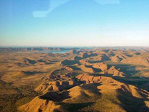
Lake Argyle was created in 1971/1972 through the construction of a dam on the Ord River . This is visible on the satellite image as a dark, meandering line. It flows north and finally flows into the Joseph Bonaparte Gulf . In addition to the Ord River, the Bow River also flows into the reservoir from the south. To the west of the reservoir are the sandstone formations of the Carr Boyd Ranges , while lower hills are on the east side.
The dam, completed in 1972, is an earthfill dam. The ratio between the volume of the dam to the storage space of the lake is the cheapest and most efficient of all dams in Australia.
The storage capacity of Lake Argyle up to the overflow at the flood relief is 10,763 million m³. The reservoir was filled for the first time in 1973 and remained so until 1984. Since then, there has been too little rainfall to fully utilize the storage capacity. The usable storage space is 5797 million m³. In the event of a flood, the overflowing reservoir can hold 35,000 million m³ and cover an area of up to 2072 km².
Landscape and geology
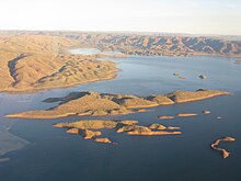
The damming of the Ord River made major changes to the environment. The outflow in the Ord River has been significantly reduced. A new, thriving ecosystem has developed in the reservoir . 26 species of fish live in the lake, the population of the freshwater crocodile is estimated at 25,000. The rise in water levels has turned a series of ridges into islands. There you can sometimes see the crocodiles and a variety of birds; Over 265 species have been documented in the area of Lake Argyle, especially in the flat alluvial land at the south end, where Ord River and Bow River meet and form a common delta.
Sandstone dominates the Carr Boyd Ranges. A geological peculiarity is the zebra stone , a microcrystalline sandstone with a zebra stripe pattern that occurs only in one place worldwide - the Miriuwung Gajerrong peninsula on the east bank of Lake Argyle. South of Kununurra there is a gallery in which handicrafts made from this rare stone are processed and sold.
Economic use
Lake Argyle, together with Lake Kununurra, which was created 10 years earlier 55 km upstream by the Ord River Diversion Dam, forms the basis of the Ord River irrigation system (so-called ORIS = Ord River Irrigation Scheme ). This irrigates about 150 km² of farmland in the East Kimberley region; an expansion to 700 km² has been planned since 2008 in an expansion phase.
The reservoir is also used to generate electricity. At the foot of the dam is the Ord Hydro Power Station , the largest renewable energy generator in Western Australia. The hydropower plant , completed in 1997, supplies the city of Kununurra, Wyndham and the Argyle Diamond Mine at the southern end of the lake. The plant generates around 210 GWh of electricity annually .
Commercially caught Neoarius midgleyi ( English called Silver Cobbler ) from the family of the cross catfish ; the catch is around 20,000 kg per year. In the years 1995-2005 there was also a Barramundi breeding farm, which produced up to 50,000 specimens annually. For this, the larvae were flown in from Queensland, pre-bred in breeding grounds outside the lake and placed in large cages in the lake to mature for 12 months. The farm was closed in June 2005. Natural barramundi stocks are limited on Lake Argyle, as these animals need salt water and are more likely to be found on the lower Ord River.
Lake Argyle Village / Durack Homestead
At the north end near the dam there is a motel with restaurant, campsite and caravan park ( Lake Argyle Village ). Shortly after the tourist center you will find a parking lot with a view of the Ord River Dam and a small part of the reservoir, which is only approx. 0.5% of the total water surface ( Lake Argyle Lookout ).
This area was first settled in 1882 by Patrick Durack , an Irish immigrant and pioneer of Western Australian cattle farming. From his former farm in West Queensland, he drove more than 7,000 cattle and 200 horses into the Kimberleys. This three year cattle drive was the longest and largest ever attempted in Australia. The eponymous original country estate of the family ( Argyle Downs , built in 1895) was demolished during the flooding in 1971 and rebuilt above the lake.
It was inhabited by Patrick Durack's granddaughter Mary , author of the autobiographical family saga Kings in Grass Castles (1959), until her death in 1994 and is now a museum ( Durack Homestead ). Two rooms are dedicated to the family history, another contains Aboriginal artifacts and a final one of the drovers' equipment.
In the garden are the graves of the family members with memorial stones and inscriptions.
Argyle diamond mine
The Argyle Diamond Mine inland at the southern end of the lake is one of the world's largest diamond producers; around 20 million carats are mined annually .
In 1979 the mining company CRA Ltd. (now the Rio Tinto Group ) diamonds found at Smoke Creek. The find was initially kept secret, as Afro-West Mining Ltd., which no longer exists today, still exists. owned mining rights in the area. CRA waited to disclose it until 1983 when they expired. In 1985 dismantling began; since then 760 million carats have been extracted. In particular, the Argyle Diamond Mine is known for its striking pink diamond, which can fetch up to 20 times the price of a white diamond of comparable size. The rough diamonds are cut and processed in Perth and India.
Workers used to be flown in from Perth; now (as of 2010) 80% come from the region, about 50% are Aborigines. With this step, the Argyle Diamond Mine has become an important employer in the eastern Kimberleys. The diamond mine can also be visited by tourists as part of a guided tour.
At Limestone Creek about 30 km away there was a second diamond mine between 1988 and 2005, the Bow River Diamond Mine . The mine, which employed 100 workers, mined 1 million carats of diamonds annually.
Infrastructure
The dam wall and Lake Argyle Village / Durack Homestead are accessible from the Victoria Highway (junction east of Kununurra) on the asphalt road .
Besides, there are no roads or paths around the banks of the lake; the parallel long-distance routes of the ( Great Northern Highway to the west and the Duncan Road to the east) are 35–50 km away without branching off accesses to the lake.
The Argyle Diamond Mine has its own airport for small aircraft. There is also a dirt track driveway from the Great Northern Highway reserved for workers residing in Argyle Village .
Tourist boats operate from Lake Argyle Village at the north end of the lake.
The dimensions of Lake Argyle can best be seen from an aerial overflight, for example on the tourist flight route from Kununurra to Purnululu National Park .
literature
- Janine Günther, Jens Mohr: Western Australia and the top end. 1st edition 2005, ISBN 3-9809763-0-0 .
- Ian Tyler: Geology and Landforms of the Kimberley. 2005, ISBN 0-7309-6852-9 .
See also
- List of the largest dams on earth
- List of the largest reservoirs on earth
- List of the largest hydroelectric plants in the world
- List of dams in the world


