Kununurra
| Kununurra | |||||||
|---|---|---|---|---|---|---|---|
 Airport Kununurra Airport |
|||||||
|
|||||||
|
|||||||
|
|||||||
|
|||||||
|
|
|||||||
| Kununurra | ||||||||||||||||||||||||||||||||||||||||||||||||
|---|---|---|---|---|---|---|---|---|---|---|---|---|---|---|---|---|---|---|---|---|---|---|---|---|---|---|---|---|---|---|---|---|---|---|---|---|---|---|---|---|---|---|---|---|---|---|---|---|
| Climate diagram | ||||||||||||||||||||||||||||||||||||||||||||||||
| ||||||||||||||||||||||||||||||||||||||||||||||||
Kununurra is a city in the extreme northeast of the Australian state of Western Australia , only a few kilometers from the border with the Northern Territory . In 2016 there were around 4,300 residents. Kununurra was founded in the 1960s for a large-scale agricultural irrigation project and has since developed into the tourist center of the Kimberley region .
The name is a corruption of the Aboriginal term Goonoonoorrang (alternatively Gananoorrang ), which means 'river' in the Miriwoong language . The city is on the Ord River .
History: The Ord River Irrigation Scheme
The state-initiated irrigation project on the Ord River, which was supposed to give the eastern Kimberley an economic boost, was implemented in two stages.
In the first stage, the Ord River Diversion Dam was built from 1961 to 1963 north of today's city, which was only built as part of this project. This dam with 20 locks was supposed to catch the water of the rainy season - about 800 mm falls annually, of which up to 80 percent between December and March - and divert it to the northeast by means of a canal system. Lake Kununurra , now a local recreation area of the city , was created by the damming .
In the second, more ambitious stage, the 100 m high Ord River Dam was built in 1971, 55 km south upstream , producing Lake Argyle . This approximately 10 billion cubic meter reservoir never becomes empty, so that the water level of the Ord River between this dam and the older Diversion Dam can be kept constant through a regulation system.
Initially, cotton was grown on around 14,000 hectares. However, the monocultures fell victim to the Heliothis caterpillars in 1974 . After various attempts with tropical fruits such as grapefruit, papayas, mangos or melons and sugar cane cultivation, which were given up in 2007 due to lack of profitability due to high transport and wage costs in the remote area, the focus has since been on sandalwood ; This concerns both the pre-cultivation of the seedlings and the cultivation of the trees, which in 2010 already took up 30 percent of the area. When the harvest is ripe, the sandalwood oil is to be extracted for the manufacture of cosmetics and medical products.
In 2008, in a further step-by-step plan, the area that could potentially be irrigated - ORIA = Ord River Irrigation Area - was expanded by a further 58,000 ha with new canals and pumping stations .
Economic good sandalwood
The sandalwood plantations are owned by TFS Corporation Ltd. , a listed West Australian company with experience in sandalwood cultivation and its processing since 1999. The Indian species Santalum album is cultivated around Kununurra , from which around 90 percent of the world exports in India come from partly illegal tropical timber. A first attempt at breeding in Australia was made on the Ord River in the tropical climate of the Kimberleys, which resulted in the world's largest plantation of this species.
A documentary will be shown to interested visitors at the Sandalwood Factory Outlets 20 km north of town. The sandalwood oil products that can be bought in these outlets , especially perfume, aftershave, massage oil, ointments, soap and candles, did not initially come from regional cultivation, but from the subsidiary Mt Romance Australia Pty Ltd. in Albany in southern Western Australia. This in turn uses an Australian sandalwood species, Santalum spicatum , which is endemic to the cool, temperate climates and which is recruited from the wild.
When the sandalwood trees in Kununurra are ready for harvest, TFS intends to produce and export from local cultivation.
Infrastructure
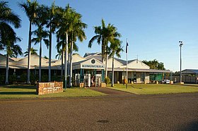
Kununurra has all the necessary utilities such as shopping center, post office, hospital, police station or gas station. The Kununurra airport can be served by commercial aircraft. Kununurra is the westernmost settlement on the Victoria Highway 45 km before it ends in the Great Northern Highway , two main long-distance routes in Australia.
Kununurra has four churches, a district high school and two smaller schools.
The tourist resort has several hotel and motel complexes as well as caravan campsites with restaurants, art galleries, leisure centers, a horse racing track and race course as well as a golf course. One of the art galleries that should be emphasized is the one that produces figures and utensils from the rare zebra stone , a microcrystalline type of sandstone with a zebra stripe pattern that is only found on Lake Argyle worldwide.
The center is very spacious, so there is no closed promenade with shops, cafés and restaurants, as they have historically grown cities such as Broome or Darwin.
North of town, four-wheel drive trails lead to Valentine Springs , Middle Springs , Black Rock Falls, and Ivanhoe Crossing waterfalls and rock pools , with picnic areas and fishing opportunities. They only have plenty of water in the rainy season, but are then also more difficult or not accessible at all.
Attractions
Kununurra itself has no sights, but owes its importance to its proximity to or infrastructural central connection to a number of attractions, to which a professional tourist administration ( visitor center with shop and video documentation) organizes guided excursions. Other destinations are more difficult to access and geared towards individualists exploring them in four-wheel drive vehicles .
Mirima National Park
The Mirima National Park, known by the Aborigines as Mirima and formerly known as the Hidden Valley, extends directly to the outskirts of Kununurra. The main attraction of the park is a spectacular canyon. There are also some sandstone cliffs , colorful wildlife and various types of eucalyptus in the park . Two hiking trails, which are not too long, lead through the park.
Keep River National Park
Keep River National Park is 36 km east of Kununurra, in the Northern Territory . There are many weathered sandstone formations here with intricate geological structures resulting from marine debris and volcanic activity. Other attractions of the park are huge bottle trees (Boab Trees). There are some Aboriginal paintings in a ravine.
Lake Argyle
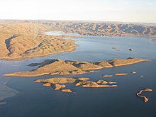
The 740 km² man-made Lake Argyle is the largest reservoir and reservoir on the continent. It is located 55 km by river and 72 km by road south of Kununurra. Swimming in the lake is not dangerous despite the many freshwater crocodiles , as they are quite shy and do not attack people. Excursion boats offer tours on the lake, during which kangaroos, birds, fish and crocodiles can be seen and which can also be bathed afterwards. There are dozens of small islands on the lake that were mountaintops of the Carr Boyd Ranges before the area was flooded . Together with Lake Kununurra, both lakes irrigate a total of 14,000 hectares of fields (as of 2010).
Boat trips on the Ord River between Ord River Dam and Diversion Dam are also offered by tourists.
Argyle Diamond Mine
The Argyle Diamond Mine produces a quarter of the world's annual diamond production ; Among other things, extremely rare pink diamonds can be found here. The mine can be visited as part of organized tours. It is located about 200 km south of Kununurra at the southern end of Lake Argyle away from the road network and is approached by small aircraft. It is a major employer in the region, especially for Aborigines, who make up half of the workforce.
Purnululu National Park
The Purnululu National Park with the globally unique bungle-bungle sandstone formation is 320 km south of Kununurra, from where sightseeing flights over the national park and guided hikes are offered.
Wyndham
100 km north of Kununurra is Wyndham , an important port city at the mouth of five major rivers. The city, surrounded by mangrove floodplain, is one of the oldest on the Australian north coast with a historic town center and a museum. The largest boab tree in Australia is in the Three Mile Caravan Park ; its trunk has a circumference of 25 m.
Hall's Creek
Halls Creek is 360 km south of Kununurra . A few kilometers to the east are the ruins of the historic gold rush town of Old Hall's Creek from 1885. Another 150 km to the south is the Wolfe Creek crater off the Tanami Road four-wheel drive . A meteorite left a 50 m deep crater with a diameter of 835 m.
literature
- Janine Günther, Jens Mohr: Western Australia and the top end. Verlag 360 °, Gamehl, 2005, ISBN 3-9809763-0-0 .
Web links
- AUSTRALIEN-INFO.DE: Description of the city, the surrounding area and its sights
- Kununurra information and route (in German)
- http://kununurra.west-oz.com/ Kununurra, Western Australia: Your Window to Western Australia
Individual evidence
- ↑ Australian Bureau of Statistics : Kununurra (Urban Center / Locality) ( English ) In: 2016 Census QuickStats . June 27, 2017. Retrieved April 7, 2020.
- ↑ Bureau of Meteorology, Australia: Klimainformationen Kununurra. World Meteorological Organization, accessed June 7, 2012 .
- ↑ Mirima Dawang Woorlab-Gerring Language and Culture Center. (No longer available online.) Archived from the original on February 28, 2016 ; accessed on May 25, 2016 . Info: The archive link was inserted automatically and has not yet been checked. Please check the original and archive link according to the instructions and then remove this notice.


