Lalubuilana
| Lalubuilana | ||
|
The Lalubuilana |
||
| Data | ||
| location | East Timor | |
| River system | Lalubuilana | |
| Source height | 200 m | |
| muzzle | in the street of Wetar Coordinates: 8 ° 25 ′ 31 ″ S , 126 ° 41 ′ 43 ″ E 8 ° 25 ′ 31 ″ S , 126 ° 41 ′ 43 ″ E
|
|
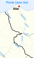
The Lalubuilana is a river in the east of East Timor .
course
The Lalubuilana rises in the border area between the Sucos Ililai ( Office of Administration loud , community loud ) and Samalari (Office of Administration Laga , community Baucau ). The Lalubuilana flows north along the border until it finally joins the Wetar Strait . Outside of the rainy season, the river falls dry.
Individual evidence
- ^ Timor-Leste GIS-Portal ( Memento from June 30, 2007 in the Internet Archive )
