Lamin Koto
| Lamin Koto | ||
|---|---|---|
|
Coordinates: 13 ° 33 ′ N , 14 ° 46 ′ W |
||
| Region: | Central River | |
| District: | Sami | |
| Residents: | 407 (2013)
|
|

|
||
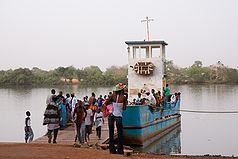
| Ferry from Janjanbureh to Lamin Koto | ||
Lamin Koto is a town in the West African state of Gambia .
According to a calculation for 2013, there are around 407 inhabitants, the result of the last published census from 1993 was 307.
geography
Lamin Koto, in the Central River Region in the Sami District on the northern bank of the Gambia River, is about 0.6 kilometers from the North Bank Road , an important highway in Gambia. To the north lies Wassu on this road about 22 kilometers away .
On the banks of the Gambia, which is around 320 meters wide, the Janjanbureh Island lies opposite. Lamin Koto operates the Janjanbureh – Lamin Koto ferry connection to the island with the town of Janjanbureh (former name: Georgetown ).
Attractions
A smaller one of the Senegambian stone circles can also be found on site. This is located about 1.3 kilometers north of the ferry dock, directly on the east side of North Bank Road under a larger tree. The formation consists of nine laterite columns , around 100 cm thick . The circle is no longer ideal because one of the stones was undermined by a tree and another one was weathered.
See also
Individual evidence
- ↑ Lamin Koto on bevoelkerungsstatistik.de (no longer available online, last accessed May 2013)
- ↑ Rosel Jahn, Wolfgang Jahn: Gambia. Travel guide with regional studies. With a travel atlas (= Mai's Weltführer. Vol. 29). Mai, Dreieich 1997, ISBN 3-87936-239-4 .
- ↑ Lamin Koto stone circle 13 ° 33 ′ 31.1 ″ N , 14 ° 45 ′ 52.2 ″ W.
- ↑ Craig Emms, Linda Barnett, Richard Human: The Gambia. The Bradt Travel Guide (= Bradt Travel Guide ). 2nd edition. Bradt Travel Guides, Chalfont St. Peter 2006, ISBN 1-84162-137-4 .
- ^ A b Michael Tomkinson: Gambia, a tourist guide. Tomkinson, London a. a. 1989, ISBN 0-905500-00-8 .

