
Wassu
| Wassu | ||
|---|---|---|
|
Coordinates: 13 ° 42 ′ N , 14 ° 53 ′ W |
||
| Region: | Central River | |
| District: | Niani | |
| Residents: | 1509 (2013)
|
|

|
||

Wassu (spelling variant: Wasu ) is a town in the West African state of Gambia .
According to a calculation for 2013, there are around 1509 inhabitants, the result of the last published census from 1993 was 1122.
geography
Wassu, in the Central River Region in the Niani District on the north bank of the Gambia River, is on the North Bank Road , an important Gambian highway , about three kilometers from Kuntaur and about 15 kilometers from Janjanbureh .
Culture and sights
The place is known for the Senegambian stone circles , among them the stone circles of Wassu are the most famous in all of Senegambia . To this end, a museum, the Wassu Stone Circles Museum , was opened at the stone circles .
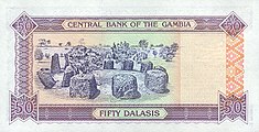
Illustration of Wassu's stone circles on a 50 Dalasi banknote (back)
-donatedsrb_b.jpg&filetimestamp=20050314214227&)
See also
Web links
Commons : Wassu - collection of images, videos and audio files
Individual evidence
- ↑ Wassu on bevoelkerungsstatistik.de (no longer available online, last accessed May 2013)
- ↑ Allen Meagher (ed.): Historic sites of The Gambia. Ada Dinkiralu (Mandinka), Bereb-I-Chosan (Wolof), Tarica Tawal (Fula), Nannin (Jola), Soninke Ada (Serehuli), I-Mofan Chosan (Serer). An official guide to the monuments and sites of The Gambia. National Council for the Arts and Culture, Banjul The Gambia 1998, ISBN 9983-80-011-014