Lamington (volcano)
| Lamington | ||
|---|---|---|
|
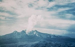
The Lamington seen from the north during the 1951 eruption |
||
| height | 1680 m | |
| location | Oro Province , Papua New Guinea | |
| Coordinates | 8 ° 56 '17 " S , 148 ° 9' 58" O | |
|
|
||
| Type | Stratovolcano | |
| Last eruption | 1956 | |
The Lamington is a stratovolcano in the province of Oro in Papua New Guinea . The volcano became famous for its eruption in January 1951, in which the place Higatura was destroyed and around 3000 people died.
The volcano is located in the southeast of the island of New Guinea about 21 kilometers south-southwest of the provincial capital Popondetta and about 35 kilometers from the coast to the Solomon Sea. Before 1951, the mountain consisted of several peaks that were arranged in a semicircle around a valley facing north. The mountain is named after Charles Cochrane-Baillie, 2nd Baron Lamington , who was Governor of Queensland from 1896 to 1901 .

Before 1951, it was not known that the forested mountain was a volcano. In later investigations, layers of ash were found, on the basis of which two eruptions could be determined around 8000 and almost 7000 years ago.
On January 15, 1951, newly formed landslides were noticed on the peaks of Lamington; later a thin column of smoke rose from there and there were light earthquakes . The numerous quakes of the following days led to the collapse of some houses. At the same time, larger and larger eruption clouds rose above the volcano, increasingly containing ash and reaching heights of seven to nine kilometers. The inhabitants of small villages located directly on the volcano began to flee.
On January 21, 1951, there was a violent eruption of magnitude 4 on the volcanic explosive index , which triggered pyroclastic currents and lahars . An area of 175 km² was completely devastated; Areas around the volcano were affected, especially the area north of the crater. The village of Higatura and several villages were destroyed; 2942 people died.
The rescue work was hampered by asphyxiating dust, sulfur fumes and the hot ash that had lasted for months. The outbreak continued, accompanied by a constant roar that could still be heard over 300 kilometers away on the island of New Britain . A lava dome built up in the crater , which had reached a height of around 300 meters on March 5th before it was destroyed by an eruption. During the eruption, meter-sized blocks were thrown three kilometers; Streams of pumice and boulders covered distances of up to 14 kilometers, setting trees on fire in the process. A second lava dome reaches a height of around 550 meters and was destroyed in mid-May. Similarly, the eruptions continued through 1956.
The Australian volcanologist Tony Taylor was awarded the George Cross in April 1952 for his contribution to the rescue work. Taylor had been at Lamington since January 1951 and, through his observations in the danger zone, contributed to saving lives and minimizing the endangerment of auxiliary workers, so the reason for the award of the medal. Taylor published a documentation and analysis of the eruptions in 1958 under the title The 1951 eruption of Mount Lamington , which became a classic among volcanological publications.
In the mid-1960s, the vegetation of the area destroyed by the pyroclastic flow resembled that of the neighboring areas. In April 2002, rumors were circulating in the Popondetta area of an impending Lamington outbreak. Investigations by the Rabaul Volcanological Observatory revealed no concrete evidence of an impending eruption. The volcano has been monitored again since 1970; earthquakes were rarely recorded.
Web links
- Lamington in the Global Volcanism Program of the Smithsonian Institution (English)
- Collection of photos of the volcanic eruption
- Lamington, New Guinea at Volcano World
- Alexander Belousov, Marina Belousova, Herman Patia, Richard Hoblitt: In the shoes of Tony Taylor. Results of reinvestigation of the 1951 eruption of Mount Lamington, Papua New Guinea. (Presentation slides, English, PDF, 4.4 MB)
- A 1951 tragedy in Papua New Guinea provides an important reference in the volcanologic literature. at the USGS ' Hawaiian Volcano Observatory
Individual evidence
- ^ Lamington - Eruptive History in the Global Volcanism Program (accessed December 23, 2012).
- ↑ a b 1951 tragedy , Hawaiian Volcano Observatory (accessed December 23, 2012).
- ^ Lamington in The Significant Volcanic Eruption Database of NOAA (accessed February 8, 2013).
- ↑ a b London Gazette (Supplement). No. 39519, HMSO, London, April 22, 1952, p. 2165 ( PDF , accessed December 24, 2012, English).
- ^ A b David Ritchie, Alexander E Gates: Encyclopedia of Earthquakes and Volcanoes. New Edition. Checkmark Books, New York 2001, ISBN 0-8160-4583-6 , p. 127.
- ↑ Lamington - Monthly Reports in the Global Volcanism Program (accessed December 24, 2012).


