
Laquette
| Laquette | ||
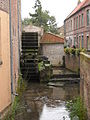
 The valley of the Laquette near Enquin-les-Mines |
||
| Data | ||
| Water code | FR : E6400750 | |
| location | France , Hauts-de-France region | |
| River system | Scheldt | |
| Drain over | Leie → Scheldt → North Sea | |
| source | in the municipality of Beaumetz-lès-Aire 50 ° 32 ′ 43 ″ N , 2 ° 13 ′ 36 ″ E |
|
| Source height | approx. 170 m | |
| muzzle | in the urban area of Aire-sur-la-Lys in the Leie coordinates: 50 ° 38 ′ 35 ″ N , 2 ° 24 ′ 10 ″ E 50 ° 38 ′ 35 ″ N , 2 ° 24 ′ 10 ″ E |
|
| Mouth height | approx. 20 m | |
| Height difference | approx. 150 m | |
| Bottom slope | approx. 6.5 ‰ | |
| length | 23 km (see notes) | |
| Small towns | Aire-sur-la-Lys | |
The Laquette is a river in France that runs in the Pas-de-Calais department in the Hauts-de-France region . It rises in the municipal area of Beaumetz-lès-Aire , initially drains north, then swings to the northeast and flows into the Leie as a right tributary after 23 kilometers in the urban area of Aire-sur-la-Lys .
Places on the river
Individual evidence
- ↑ a b geoportail.fr (1: 16,000)
- ↑ The information on the length of the river is based on the information on the Laquette at SANDRE (French), accessed on June 8, 2010, rounded to full kilometers.
The river in Aire-sur-la-Lys

Muzzle into the Leie

