
Estrée-Blanche
| Estrée-Blanche | ||
|---|---|---|
|
||
| region | Hauts-de-France | |
| Department | Pas-de-Calais | |
| Arrondissement | Bethune | |
| Canton | Aire-sur-la-Lys | |
| Community association | Béthune-Bruay, Artois-Lys novels | |
| Coordinates | 50 ° 36 ′ N , 2 ° 19 ′ E | |
| height | 37-99 m | |
| surface | 5.32 km 2 | |
| Residents | 951 (January 1, 2017) | |
| Population density | 179 inhabitants / km 2 | |
| Post Code | 62145 | |
| INSEE code | 62313 | |
| Website | http://www.estree-blanche.fr/ | |
_mairie.JPG) Town hall (Mairie) of Estrée-Blanche |
||

Estrée-Blanche ( Flemish : Strate ) is a French municipality with 951 inhabitants (as of January 1 2017) in the department of Pas-de-Calais in the region of Hauts-de-France . It belongs to the arrondissement of Béthune and the canton of Aire-sur-la-Lys (until 2015: canton of Norrent-Fontes ).
geography
Estrée-Blanche is located about 23 kilometers west-northwest of Béthune . Estrée-Blanche is surrounded by the neighboring communities of Blessy in the north and northeast, Liettres in the east, Rely in the southeast, Ligny-lès-Aire in the south and Enquin-lez-Guinegatte in the west and southwest.
The A26 autoroute runs through the municipality .
Population development
| year | 1962 | 1968 | 1975 | 1982 | 1990 | 1999 | 2006 | 2013 |
| Residents | 1,164 | 1,093 | 1,068 | 1.005 | 988 | 928 | 911 | 950 |
| Source: Cassini and INSEE | ||||||||
Attractions
- Saint-Vaast church from the 16th century
- Créminil Castle from the 15th century
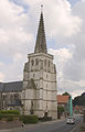
Saint-Vaast church
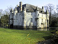
Créminil Castle


Web links
Commons : Estrée-Blanche - collection of images, videos and audio files
Individual evidence
- ^ De Nederlanden in Frankrijk, Jozef van Overstraeten, 1969