Camblain-Châtelain
| Camblain-Châtelain | ||
|---|---|---|

|
|
|
| region | Hauts-de-France | |
| Department | Pas-de-Calais | |
| Arrondissement | Bethune | |
| Canton | Auchel | |
| Community association | Béthune-Bruay, Artois-Lys novels | |
| Coordinates | 50 ° 29 ′ N , 2 ° 28 ′ E | |
| height | 51-177 m | |
| surface | 10.04 km 2 | |
| Residents | 1,764 (January 1, 2017) | |
| Population density | 176 inhabitants / km 2 | |
| Post Code | 62470 | |
| INSEE code | 62197 | |
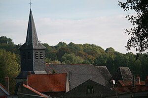
 Saint-Vaast church |
||
Camblain-Chatelain is a French commune with 1,764 inhabitants (at January 1, 2017) in the department of Pas-de-Calais in the region of Hauts-de-France .
geography
The municipality is located on the Clarence , about eleven kilometers southwest of Béthune and about 53 kilometers southwest of Lille .
Population development
- 1962 = 1904
- 1968 = 1956
- 1975 = 1880
- 1982 = 1710
- 1990 = 1629
- 1999 = 1581
Attractions
- Ruins of a castle from the 11th century
- St. Vaast Church from the 15th century
Web links
Commons : Camblain-Châtelain - collection of images, videos and audio files
