
Saint-Hilaire-Cottes
| Saint-Hilaire-Cottes | ||
|---|---|---|

|
|
|
| region | Hauts-de-France | |
| Department | Pas-de-Calais | |
| Arrondissement | Bethune | |
| Canton | Aire-sur-la-Lys | |
| Community association | Béthune-Bruay, Artois-Lys novels | |
| Coordinates | 50 ° 34 ′ N , 2 ° 25 ′ E | |
| height | 24-102 m | |
| surface | 7.24 km 2 | |
| Residents | 807 (January 1, 2017) | |
| Population density | 111 inhabitants / km 2 | |
| Post Code | 62120 | |
| INSEE code | 62750 | |
| Website | http://www.sainthilairecottes62.fr/ | |
_mairie.JPG) Town hall (Mairie) of Saint-Hilaire-Cottes |
||

Saint-Hilaire-Cottes is a French municipality with 807 inhabitants (as of January 1 2017) in the department of Pas-de-Calais in the region of Hauts-de-France . It belongs to the arrondissement of Béthune and the canton of Aire-sur-la-Lys (until 2015: canton of Norrent-Fontes ).
geography
Saint-Hilaire-Cottes is about 16 kilometers west-northwest of Béthune . Saint-Hilaire-Cottes is surrounded by the neighboring communities of Norrent-Fontes in the north, Bourecq in the east, Lespesses in the south-east, Lières in the south, Auchy-au-Bois in the south-west and Rely in the west.
Population development
| year | 1962 | 1968 | 1975 | 1982 | 1990 | 1999 | 2006 | 2013 |
| Residents | 769 | 775 | 725 | 752 | 750 | 734 | 798 | 812 |
| Source: Cassini and INSEE | ||||||||
Attractions
- Saint-Hilaire church in Saint-Hilaire from the 18th century
- Saint-Omer church in Cottes from the 15th century
- Notre-Dame-d'Immaculée-Conception chapel in Cottes from 1884
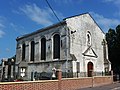
Saint-Hilaire church

Saint-Omer church

Notre-Dame-d'Immaculée-Conception chapel
_%C3%A9glise_de_Saint-Hilaire.JPG)
_%C3%A9glise_de_Cottes.JPG)
_chapelle_N.D.d%27Immacul%C3%A9e_Conception,_Cottes.JPG)
Web links
Commons : Saint-Hilaire-Cottes - Collection of images, videos and audio files