La Couture (Pas-de-Calais)
| La Couture | ||
|---|---|---|

|
|
|
| region | Hauts-de-France | |
| Department | Pas-de-Calais | |
| Arrondissement | Bethune | |
| Canton | Beuvry | |
| Community association | Béthune-Bruay, Artois-Lys novels | |
| Coordinates | 50 ° 35 ' N , 2 ° 43' E | |
| height | 15-20 m | |
| surface | 13.52 km 2 | |
| Residents | 2,764 (January 1, 2017) | |
| Population density | 204 inhabitants / km 2 | |
| Post Code | 62136 | |
| INSEE code | 62252 | |
| Website | http://www.lacouture62.fr/ | |
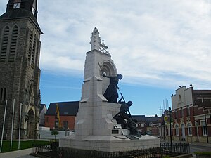
 Town center with church, memorial and town hall |
||
La Couture ( Flemish : De Kouter ) is a French municipality with 2764 inhabitants (as of January 1 2017) in the department of Pas-de-Calais in the region of Hauts-de-France . La Couture belongs to the arrondissement of Béthune and since 2015 to the canton of Beuvry (before: canton of Béthune-Est ). The municipality is a member of the Béthune-Bruay municipal association , Artois-Lys Romane .
geography
La Couture is located in the Artois between the Lawe and Loisne rivers . La Couture is surrounded by the neighboring communities of Lestrem in the north and north-west, Vieille-Chapelle in the north, Richebourg in the east, Festubert in the south, Beuvry in the south and south-west and Locon in the west.
history
During the First World War, the Portuguese expeditionary force defended the community here. A memorial was set up in 1928.
Population development
| 1962 | 1968 | 1975 | 1982 | 1990 | 1999 | 2006 | 2012 |
|---|---|---|---|---|---|---|---|
| 1,303 | 1,327 | 1,332 | 1,666 | 2.165 | 2,249 | 2,579 | 2.712 |
Attractions
- Saint-Pierre church
- Memorial to the Portuguese Expeditionary Force
Parish partnership
There is a partnership with the Portuguese municipality of Murça in the Vila Real district .
