
Vendin-lès-Béthune
| Vendin-lès-Béthune | ||
|---|---|---|

|
|
|
| region | Hauts-de-France | |
| Department | Pas-de-Calais | |
| Arrondissement | Bethune | |
| Canton | Bethune | |
| Community association | Béthune-Bruay, Artois-Lys novels | |
| Coordinates | 50 ° 33 ' N , 2 ° 36' E | |
| height | 21-45 m | |
| surface | 3.63 km 2 | |
| Residents | 2,443 (January 1, 2017) | |
| Population density | 673 inhabitants / km 2 | |
| Post Code | 62232 | |
| INSEE code | 62841 | |
| Website | http://www.vendin-lez-bethune.fr/ | |

Vendin-les-Bethune ( Flemish : Contact ) is a French municipality with 2443 inhabitants (as of January 1 2017) in the department of Pas-de-Calais in the region of Hauts-de-France ; it belongs to the arrondissement of Béthune and the canton of Béthune (until 2015: canton of Béthune-Nord ). The inhabitants are called Vendinois (es) .
geography
Vendin-lès-Béthune is located about three kilometers northwest of Béthune . Vendin-lès-Béthune is surrounded by the neighboring communities of Gonnehem in the north and northwest, Hinges in the north and northeast, Annezin in the south and east, Chocques in the west and southwest and Oblinghem in the west and northwest.
The former Route nationale 43 (today's D943) runs along the southern edge of the municipality .
Population development
| year | 1962 | 1968 | 1975 | 1982 | 1990 | 1999 | 2006 | 2012 |
|---|---|---|---|---|---|---|---|---|
| Residents | 2,026 | 2,040 | 2,533 | 2,302 | 2,450 | 2,526 | 2,430 | 2,401 |
Attractions
- Saint-Vaast church from the 19th century
- War memorial

town hall
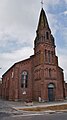
Saint-Vaast church
.JPG)
.JPG)
Web links
Individual evidence
- ^ De Nederlanden in Frankrijk, Jozef van Overstraeten, 1969