Fleurbaix
| Fleurbaix | ||
|---|---|---|

|
|
|
| region | Hauts-de-France | |
| Department | Pas-de-Calais | |
| Arrondissement | Bethune | |
| Canton | Beuvry | |
| Community association | Flandre Lys | |
| Coordinates | 50 ° 39 ′ N , 2 ° 50 ′ E | |
| height | 16-20 m | |
| surface | 12.86 km 2 | |
| Residents | 2,732 (January 1, 2017) | |
| Population density | 212 inhabitants / km 2 | |
| Post Code | 62840 | |
| INSEE code | 62338 | |
| Website | http://fleurbaix.com/ | |
Fleurbaix ( Dutch : Vloerbeek ) is a French municipality with 2732 inhabitants (as of January 1 2017) in the department of Pas-de-Calais in the region of Hauts-de-France . It belongs to the Arrondissement of Béthune and the Canton of Beuvry (until 2015: Canton Laventie ). The inhabitants are called Fleurbaisiens .
geography
Fleurbaix is located in the historical region of Flanders near the border with the Nord department . The community is located on the Becque du Biez brook . Fleurbaix is surrounded by the neighboring communities of Erquinghem-Lys in the north, Bois-Grenier in the northeast, Le Maisnil in the east, Fromelles in the southeast, Aubers in the south, Laventie in the southwest and Sailly-sur-la-Lys in the west.
Population development
| year | 1962 | 1968 | 1975 | 1982 | 1990 | 1999 | 2006 | 2011 |
| Residents | 1,437 | 1,457 | 1,647 | 1.993 | 2,221 | 2,480 | 2,674 | 2,635 |
Attractions
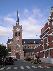
- Notre-Dame du Joyel church, built in 1929
- former Carthusian monastery Notre-Dame des Sept Douleurs de la Boutillerie (existed from 1618 to 1792)
- Trou Aid Post Cemetery, British military cemetery
Web links
Commons : Fleurbaix - collection of images, videos and audio files

