
Aubers
| Aubers | ||
|---|---|---|
_Nord-france.svg)
|
|
|
| region | Hauts-de-France | |
| Department | North | |
| Arrondissement | Lille | |
| Canton | Annœullin | |
| Community association | Métropole Européenne de Lille | |
| Coordinates | 50 ° 36 ′ N , 2 ° 50 ′ E | |
| height | 18-41 m | |
| surface | 10.14 km 2 | |
| Residents | 1,651 (January 1, 2017) | |
| Population density | 163 inhabitants / km 2 | |
| Post Code | 59249 | |
| INSEE code | 59025 | |
| Website | http://www.aubers.fr/ | |
 Aubers seen from Fauquissart |
||

Auber is a French commune with 1,651 inhabitants (at January 1, 2017) in Nord in the region of Hauts-de-France .
location
Aubers is on the border with the Pas-de-Calais department , 20 kilometers southwest of Lille and 15 kilometers east of Béthune . Neighboring communities are Fleurbaix , Fromelles , Herlies , Illies , Lorgies , Neuve-Chapelle and Laventie .
history
The parish is located in an area that was long fought over during the First World War . There was a war of position with many bloody grave struggles . There are numerous military cemeteries in the region, some with memorial monuments.
Some of the fighting was aimed at gaining control of the plain between the rivers Deûle and Leie (French: Lys ). A large part of the commune was destroyed; the residents had to flee. The village was completely shot by shells. Only a linden tree, which had been split in two by lightning in 1721, miraculously remained. Today this linden tree has a trunk circumference of about eight meters.
The soldiers who died in the fighting were initially temporarily buried and later collected at Aubers Ridge British Cemetery .
The reconstruction of Belgium and northern France began in 1919 with a large mine clearance operation (under the control of the British Army) because there were numerous duds in the ground . A major metal shortage after the war was also an incentive to collect them. There were specialized "centers de tri et de démantèlement" (iron foundries that had concessions for this).

Church ruins in 1914

Market square and church 1914

Village center, June 1915


Attractions
- Le Domaine de L'Hippocrate riding school
- Joncquoy's linden tree (planted 1490)
- two "Châteaux de Piètre" (castles with moats)
- an area with ponds and fishing ponds (5 hectares)
- Notre-Dame-de-Lourdes grotto (since 1958)
See also: List of Monuments historiques in Aubers

church

War memorial
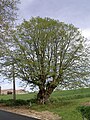
Linden by Joncquoy in Aubers


literature
- Le Patrimoine des Communes du Nord. Flohic Editions, Volume 1, Paris 2001, ISBN 2-84234-119-8 , pp. 191-193.