Neuville-en-Ferrain
| Neuville-en-Ferrain | ||
|---|---|---|

|
|
|
| region | Hauts-de-France | |
| Department | North | |
| Arrondissement | Lille | |
| Canton | Tourcoing-1 | |
| Community association | Métropole Européenne de Lille | |
| Coordinates | 50 ° 45 ′ N , 3 ° 10 ′ E | |
| height | 30-52 m | |
| surface | 6.18 km 2 | |
| Residents | 10,284 (January 1, 2017) | |
| Population density | 1,664 inhabitants / km 2 | |
| Post Code | 59960 | |
| INSEE code | 59426 | |
| Website | http://www.neuville-en-ferrain.fr// | |
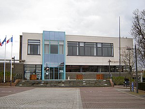
 Town hall of Neuville-en-Ferrain |
||
Neuville-en-Ferrain is a French municipality with 10,284 inhabitants (as of January 1 2017) in the department of Nord in the region of Hauts-de-France . The inhabitants are called Neuvilloise .
geography
The municipality is located in the Lille agglomeration , right on the Belgian border. Neighboring communities are Halluin in the north-west, Mouscron (Belgium) in the north and east, Tourcoing in the south and Roncq in the west.
history
The origins of the place go back to the 11th century. With the Treaty of Aachen , the place became French in 1668. Neuville-en-Ferrain has been a border town with Belgium since 1820.
Attractions
See also: List of Monuments historiques in Neuville-en-Ferrain
- Saint-Quirin church from 1500
- Bourloire du cercle Saint-Joseph ( monument since 2006 )
Community partnerships
Neuville-en-Ferrain maintains community partnerships with the following communities:
- Offenbach an der Queich , Rhineland-Palatinate, Germany, since 1992
- Keur Madiabel , Senegal, since 2002
There is a friendship treaty with the Canadian city of Sainte-Anne-des-Plaines in the province of Québéc.
Personalities
- Robert Desmettre (1901-1936), water polo player
- Noël Liétaer (1908–1941), football player
literature
- Le Patrimoine des Communes du Nord. Flohic Editions, Volume 2, Paris 2001, ISBN 2-84234-119-8 , pp. 1569-1570.

