Houplines
| Houplines | ||
|---|---|---|

|
|
|
| region | Hauts-de-France | |
| Department | North | |
| Arrondissement | Lille | |
| Canton | Armentières | |
| Community association | Métropole Européenne de Lille | |
| Coordinates | 50 ° 41 ′ N , 2 ° 55 ′ E | |
| height | 12-20 m | |
| surface | 11.32 km 2 | |
| Residents | 7,805 (January 1, 2017) | |
| Population density | 689 inhabitants / km 2 | |
| Post Code | 59116 | |
| INSEE code | 59317 | |
| Website | http://www.ville-houplines.fr/ | |
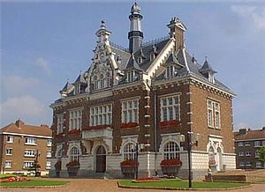
 Houplines Town Hall |
||
Houplines (NDL .: "Opline") is a French municipality with 7805 inhabitants (at January 1, 2017) in Nord in the region of Hauts-de-France . It belongs to the arrondissement of Lille and the canton of Armentières .
Neighboring municipalities of Houplines are Comines-Warneton (district Ploegsteert ) in the north, Frelinghien in the northeast, Pérenchies in the southeast, Prémesques in the south, La Chapelle-d'Armentières in the southwest and Armentières in the west.
Population development
| year | 1962 | 1968 | 1975 | 1982 | 1990 | 1999 | 2007 | 2017 |
| Residents | 5934 | 6398 | 7403 | 7924 | 7609 | 7862 | 7570 | 7805 |
Attractions
- Hotel de ville
- Saint-Charles church
- Church of Sainte-Anastasie (see also: List of Monuments historiques in Houplines )
- Les Cimetières du Commonwealth (Houplines Communal Cemetery Extension and Ferme Buterne Military Cemetery) - all from the post World War I.
Community partnerships
- Kirchhundem (North Rhine-Westphalia)
literature
- Le Patrimoine des Communes du Nord. Flohic Editions, Volume 1, Paris 2001, ISBN 2-84234-119-8 , pp. 107-110.
Web links
Commons : Houplines - collection of images, videos and audio files
Individual evidence
- ^ De Nederlanden in Frankrijk, Jozef van Overstraeten, 1969


