Bondues
| Bondues | ||
|---|---|---|

|
|
|
| region | Hauts-de-France | |
| Department | North | |
| Arrondissement | Lille | |
| Canton | Lille-2 | |
| Community association | Métropole Européenne de Lille | |
| Coordinates | 50 ° 42 ′ N , 3 ° 6 ′ E | |
| height | 18-53 m | |
| surface | 13.05 km 2 | |
| Residents | 10,103 (January 1, 2017) | |
| Population density | 774 inhabitants / km 2 | |
| Post Code | 59910 | |
| INSEE code | 59090 | |
| Website | www.ville-bondues.fr | |
 Château du Vert Bois |
||
Bondues ( Flemish : Bonduwe ) is a French city with 10,103 inhabitants (as of January 1 2017) in the department of Nord in the region of Hauts-de-France . Bondues belongs to the arrondissement of Lille and is part of the canton of Lille-2 . The inhabitants are called Bonduois .
geography
Bondues is located in the north of the Lille metropolis , about 10 kilometers from the Belgian border, on the A22 motorway . The Lille-Marcq-en-Barœul airport is on the outskirts . Bondues is surrounded by the neighboring municipalities of Linselles and Roncq in the north, Tourcoing in the east, Mouvaux in the southeast, Marcq-en-Barœul in the south, Marquette-lez-Lille in the southwest and Wambrechies in the west.
Population development
| year | 1962 | 1968 | 1975 | 1982 | 1990 | 1999 | 2006 | 2017 |
| Residents | 3574 | 3961 | 6706 | 8840 | 10,281 | 10,680 | 10.151 | 10,103 |
Attractions
See also: List of Monuments historiques in Bondues
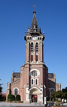
- Church Saint-Vaast from the late 19th century
- Le Vert-Bois Castle and Park ( Monument historique )
- La Vigne castle with park
- Fort de Bondues (also: Fort Lobau), fortification built between 1877 and 1880, today: Museum of the Resistance
Community partnerships
Bondues has twinned cities
- Haywards Heath , West Sussex (England), United Kingdom, since 1998
- Wülfrath , North Rhine-Westphalia, Germany, since 2003
- Buduslău , Romania, since 2003
Personalities
- Eugène Dodeigne (1923–2015), sculptor
literature
- Le Patrimoine des Communes du Nord. Flohic Editions, Volume 2, Paris 2001, ISBN 2-84234-119-8 , pp. 1189-1199.
Web links
Individual evidence
- ↑ Bondues Jumelage , accessed September 28, 2017

