Avelin
| Avelin | ||
|---|---|---|

|
|
|
| region | Hauts-de-France | |
| Department | North | |
| Arrondissement | Lille | |
| Canton | Templeuve | |
| Community association | Pévèle-Carembault | |
| Coordinates | 50 ° 32 ' N , 3 ° 5' E | |
| height | 29-58 m | |
| surface | 13.76 km 2 | |
| Residents | 2,690 (January 1, 2017) | |
| Population density | 195 inhabitants / km 2 | |
| Post Code | 59710 | |
| INSEE code | 59034 | |
| Website | http://www.mairie-avelin.fr/ | |
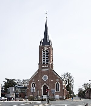
 Saint-Quentin Church |
||
Avelin is a French commune with 2,690 inhabitants (as of January 1 2017) in the department of Nord in the region of Hauts-de-France . It belongs to the arrondissement of Lille and is part of the canton of Templeuve . The inhabitants call themselves Avelinois (es) .
geography
Avelin is about ten kilometers south of Lille . Avelin is surrounded by the neighboring communities of Vendeville in the north, Fretin in the northeast, Ennevelin in the east, Pont-à-Marcq and Mérignies in the southeast, Tourmignies in the south, Attiches in the southwest, Seclin in the west and Templemars in the northwest.
The former Route nationale 49 (D549) runs through the municipality . The Lille-Lesquin Airport is due in large part to the municipality of Avelin.
Population development
| 1962 | 1968 | 1975 | 1982 | 1990 | 1999 | 2006 | 2012 |
|---|---|---|---|---|---|---|---|
| 1,391 | 1.306 | 1,292 | 1,817 | 2,317 | 2,304 | 2,451 | 2,590 |
Attractions
See also: List of Monuments historiques in Avelin
- Saint-Quentin Church in Avelin
- Saint-Vincent church in Ennetières
- British military cemeteries at Avelin and Ennetières
literature
- Le Patrimoine des Communes du Nord. Flohic Editions, Volume 2, Paris 2001, ISBN 2-84234-119-8 , p. 1294.
