Mons-en-Pévèle
| Mons-en-Pévèle | ||
|---|---|---|

|
|
|
| region | Hauts-de-France | |
| Department | North | |
| Arrondissement | Lille | |
| Canton | Templeuve | |
| Community association | Pévèle-Carembault | |
| Coordinates | 50 ° 29 ′ N , 3 ° 6 ′ E | |
| height | 32-107 m | |
| surface | 12.37 km 2 | |
| Residents | 2,134 (January 1, 2017) | |
| Population density | 173 inhabitants / km 2 | |
| Post Code | 59246 | |
| INSEE code | 59411 | |
| Website | http://mairie-monsenpevele.fr/ | |
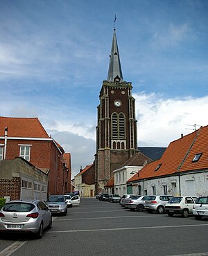
 Saint Jean-Baptiste church |
||
Mons-en-Pévèle (NDL .: "Pevelenberg") is a French municipality with 2,134 inhabitants (at January 1, 2017) in the department of Nord in the region of Hauts-de-France . It belongs to the arrondissement of Lille and the canton of Templeuve . The place is named after the Pévèle landscape , one of the “quarters” of the Burgraviate of Lille .
history
- The battle of Mons-en-Pévèle took place on August 18, 1304 near the place.
Population development
| 1962 | 1968 | 1975 | 1982 | 1990 | 1999 |
|---|---|---|---|---|---|
| 1,875 | 1.921 | 1,962 | 2,180 | 2,064 | 2,054 |
From 1962 only residents with primary residence
literature
- Le Patrimoine des Communes du Nord. Flohic Editions, Volume 2, Paris 2001, ISBN 2-84234-119-8 , pp. 1302-1303.
Web links
Commons : Mons-en-Pévèle - Collection of images, videos and audio files
Individual evidence
- ^ De Nederlanden in Frankrijk, Jozef van Overstraeten, 1969
