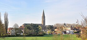
Saint-Venant
| Saint-Venant | ||
|---|---|---|

|
|
|
| region | Hauts-de-France | |
| Department | Pas-de-Calais | |
| Arrondissement | Bethune | |
| Canton | Lillers | |
| Community association | Béthune-Bruay, Artois-Lys novels | |
| Coordinates | 50 ° 37 ' N , 2 ° 33' E | |
| height | 15-19 m | |
| surface | 14.24 km 2 | |
| Residents | 3,027 (January 1, 2017) | |
| Population density | 213 inhabitants / km 2 | |
| Post Code | 62350 | |
| INSEE code | 62770 | |
| Website | http://www.saint-venant.fr/ | |
 Saint-Venant town hall |
||
Saint-Venant (Flemish: Papingem ) is a French municipality with 3027 inhabitants (as of January 1 2017) in the department of Pas-de-Calais in the region of Hauts-de-France . It belongs to the Arrondissement of Béthune and the Canton of Lillers . The inhabitants are called Saint-Venantais .
geography
Saint-Venant is surrounded by the neighboring communities Haverskerque in the north, Saint-Floris in the east, Robecq in the south and south-east, Busnes in the south, Guarbecque in the south-west, Isbergues in the west and Aire-sur-la-Lys and Thiennes in the north-west.
The place is located on the southern, right bank of the Leie , into which the Guarbecque and Busnes rivers, named after the respective neighboring communities, flow.
Population development
| year | 1962 | 1968 | 1975 | 1982 | 1990 | 1999 | 2006 | 2011 |
| Residents | 4.029 | 4,328 | 3,988 | 4.127 | 3,887 | 3,206 | 3,260 | 3,035 |
Attractions
- Saint-Venant church, rebuilt in 1918 with a 16th century bell tower
- Town hall from 1776, monument historique since 1951
- 18th century houses and farms
- British military cemetery
Personalities
- Robert de Waurin (died 1360), Marshal of France in 1344
- Charles-Louis-Félix Franchot (1809–1881), inventor and designer
Web links
Commons : Saint-Venant - Collection of images, videos and audio files
Individual evidence
- ^ De Nederlanden in Frankrijk, Jozef van Overstraeten, 1969


