
Enquin-lez-Guinean husband
| Enquin-lez-Guinean husband | ||
|---|---|---|
|
||
| region | Hauts-de-France | |
| Department | Pas-de-Calais | |
| Arrondissement | Saint-Omer | |
| Canton | Fruges | |
| Community association | Pays de Saint-Omer | |
| Coordinates | 50 ° 37 ′ N , 2 ° 16 ′ E | |
| height | 49-132 m | |
| surface | 20.02 km 2 | |
| Residents | 1,616 (January 1, 2017) | |
| Population density | 81 inhabitants / km 2 | |
| Post Code | 62145 | |
| INSEE code | 62295 | |
_mairie.JPG) Town hall (Mairie) of Enquin-lez-Guinegatte |
||

Enquin-lez-Guinegatte is a municipality in northern France with 1,616 inhabitants (as of January 1, 2017). It belongs to the Hauts-de-France region , the Nord department , the Saint-Omer arrondissement and the Fruges canton .
1 January 2017 were Enquin-les-Mines and Enguinegatte the new municipality ( commune nouvelle ) Enquin-lez-Guinegatte combined.
geography
Enquin-lez-Guinegatte is about 16 kilometers south of Saint-Omer and borders Thérouanne in the north and northwest, Mametz in the northeast, Blessy and Estrée-Blanche in the east, Ligny-lès-Aire in the southeast, Febvin-Palfart and Fléchin in the south , Erny-Saint-Julien in the southwest and Delettes in the west and northwest.
structure
| District | former INSEE code |
Area (km²) | Population (2016) |
|---|---|---|---|
| Enguine spouse | 62294 | 8.92 | 456 |
| Enquin-les-Mines (administrative headquarters) | 62295 | 11.10 | 1,163 |
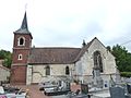
Attractions
- Church of Flechinelle
- Enquin Church
- Serny Church
- Remains of the estate of the Knights Templar
Church of Flechinelle

Enquin Church

Serny Church

Manor of the Knights Templar
_%C3%A9glise_de_Flechinelle.JPG)
_%C3%A9glise_d%27Enquin.JPG)
_%C3%A9glise_de_Serny_(02).JPG)
_ferme_des_Templiers_%C3%A0_Flechinelle.JPG)
Web links
Individual evidence
- ↑ Population figures retrospectively from January 1, 2016