
Wardrecques
| Wardrecques | ||
|---|---|---|

|
|
|
| region | Hauts-de-France | |
| Department | Pas-de-Calais | |
| Arrondissement | Saint-Omer | |
| Canton | Fruges | |
| Community association | Pays de Saint-Omer | |
| Coordinates | 50 ° 43 ′ N , 2 ° 21 ′ E | |
| height | 21-69 m | |
| surface | 3.72 km 2 | |
| Residents | 1,333 (January 1, 2017) | |
| Population density | 358 inhabitants / km 2 | |
| Post Code | 62120 | |
| INSEE code | 62875 | |
| Website | http://www.commune-wardrecques.com/ | |
.JPG) Town Hall (Mairie) of Wardrecques |
||

Wardrecques ( Flemish : Werdrik ) is a French municipality with 1,333 inhabitants (as of January 1 2017) in the department of Pas-de-Calais in the region of Hauts-de-France . It belongs to the arrondissement of Saint-Omer and the canton of Fruges (until 2015: canton of Aire-sur-la-Lys ).
geography
Wardrecques is located about seven kilometers southeast of Saint-Omer and about 28 kilometers northwest of Béthune on the Canal de Neuffossé . The municipality is associated with the Caps et Marais d'Opale Regional Nature Park as an access point .
Wardrecques is surrounded by the neighboring communities of Campagne-lès-Wardrecques in the north and west, Renescure in the north-east, Blaringhem in the east and south-east, Racquinghem in the south and east and Heuringhem in the south and south-west.
Population development
| year | 1962 | 1968 | 1975 | 1982 | 1990 | 1999 | 2006 | 2013 |
| Residents | 518 | 530 | 541 | 946 | 1,034 | 1,068 | 1,153 | 1.306 |
| Source: Cassini and INSEE | ||||||||
Attractions
- Notre-Dame church
- Quénivet Chapel from the 18th century

Notre-Dame church
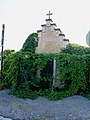
Quénivet Chapel
_%C3%89glise_Notre_Dame_(01).JPG)
_oratoire_D190-D199.JPG)