
Saint-Martin-lez-Tatinghem
| Saint-Martin-lez-Tatinghem | ||
|---|---|---|
|
||
| region | Hauts-de-France | |
| Department | Pas-de-Calais | |
| Arrondissement | Saint-Omer | |
| Canton | Saint-Omer | |
| Community association | Pays de Saint-Omer | |
| Coordinates | 50 ° 45 ' N , 2 ° 14' E | |
| height | 1-88 m | |
| surface | 11.54 km 2 | |
| Residents | 5,906 (January 1, 2017) | |
| Population density | 512 inhabitants / km 2 | |
| Post Code | 62500 | |
| INSEE code | 62757 | |
.JPG) Town hall (Mairie) of Saint-Martin-lez-Tatinghem |
||

Saint-Martin-lez-Tatinghem is a commune in northern France with 5,906 inhabitants (as of January 1, 2017). It belongs to the Hauts-de-France region , the Nord department , the Saint-Omer arrondissement and the Saint-Omer canton (until 2015: Saint-Omer-Nord canton ).
1 January 2016 were Saint-Martin-au-Laërt and Tatinghem the new municipality ( commune nouvelle ) Saint-Martin-lez-Tatinghem combined.
geography
Saint-Martin-lez-Tatinghem is located about three kilometers west of Saint-Omer and is bordered by Salperwick in the north, Saint-Omer in the east and west, Longuenesse in the south and southeast, Wisques in the southwest, Leulinghem in the west and southwest and Zudausques in the West. The municipality is part of the Caps et Marais d'Opale Regional Nature Park .
structure
| District | former INSEE code |
Area (km²) | Population (2016) |
|---|---|---|---|
| Saint-Martin-au-Laërt (administrative headquarters) | 62757 | 4.94 | 4,006 |
| Tatinghem | 62807 | 5.60 | 1,891 |
Attractions
- Saint-Martin church in Saint-Martin-au-Laërt
- Saint-Jacques church in Tatinghem
- Mill
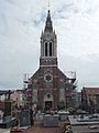
Saint Martin Church

Saint-Jacques church
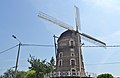
Mill
_%C3%A9glise_(01).JPG)
_%C3%89glise_Saint-Jacques_(03).JPG)
.JPG)
Web links
Individual evidence
- ↑ Population figures retrospectively from January 1, 2016