
Helfaut
| Helfaut | ||
|---|---|---|

|
|
|
| region | Hauts-de-France | |
| Department | Pas-de-Calais | |
| Arrondissement | Saint-Omer | |
| Canton | Longuenesse | |
| Community association | Pays de Saint-Omer | |
| Coordinates | 50 ° 42 ′ N , 2 ° 15 ′ E | |
| height | 23-95 m | |
| surface | 8.92 km 2 | |
| Residents | 1,697 (January 1, 2017) | |
| Population density | 190 inhabitants / km 2 | |
| Post Code | 62570 | |
| INSEE code | 62423 | |
| Website | http://www.commune-helfaut.fr/ | |
_mairie_et_%C3%A9coles.JPG) Town hall (Mairie) and school of Helfaut |
||

Helfaut ( Dutch : Helveld ) is a French municipality with 1697 inhabitants (as of January 1 2017) in the department of Pas-de-Calais and the region Nord-Pas-de-Calais . The municipality belongs to the arrondissement Saint-Omer and is part of the canton Longuenesse (until 2015: canton Arques ). The inhabitants are called Helfalois .
geography
Helfaut is about 39 kilometers southeast of Calais . The municipality is part of the Caps et Marais d'Opale Regional Nature Park .
Helfaut is surrounded by the neighboring communities of Wizernes in the north and northwest, Blendecques in the northeast, Heuringhem in the east, Ecques in the southeast, Inghem in the south, Pihem in the west and southwest and Hallines in the west and northwest.
Population development
| 1962 | 1968 | 1975 | 1982 | 1990 | 1999 | 2006 | 2012 | |
|---|---|---|---|---|---|---|---|---|
| 1,000 | 1,139 | 1,248 | 1,426 | 1,671 | 1,693 | 1,744 | 1,596 | |
| Sources: Cassini and INSEE | ||||||||
Attractions
- Saints-Fuscian-et-Victoric church from the 16th / 17th centuries Century, parts from the 12th century
- Church of Saint Denis in the village of Bilques from the 17th / 18th centuries century
- Notre-Dame-de-Lourdes chapel in Bilques
- Calvaire
- Town hall with school
- Old sanatorium
- Dome of Helfaut-Wizernes , under the code name Schotterwerk Nordwest in 1943/1944 operated bunker for V2 rockets
- British military cemetery

Saints-Fuscian-et-Victoric church

Saint-Denis church
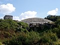
Helfaut-Wizernes dome
_%C3%89glise_Saints-Fuscien-et-Victoric_d%27Helfaut.JPG)
_%C3%A9glise_Saint-Denis_de_Bilques,_chevet.JPG)
