
Moringhem
| Moringhem | ||
|---|---|---|

|
|
|
| region | Hauts-de-France | |
| Department | Pas-de-Calais | |
| Arrondissement | Saint-Omer | |
| Canton | Saint-Omer | |
| Community association | Pays de Saint-Omer | |
| Coordinates | 50 ° 46 ′ N , 2 ° 8 ′ E | |
| height | 37-166 m | |
| surface | 9.98 km 2 | |
| Residents | 558 (January 1, 2017) | |
| Population density | 56 inhabitants / km 2 | |
| Post Code | 62910 | |
| INSEE code | 62592 | |

Moringhem ( Flemish : Moringem ) is a municipality in northern France with 558 inhabitants (as of January 1, 2017). It belongs to the Hauts-de-France region , the Nord department , the Saint-Omer arrondissement and the Saint-Omer canton (until 2015: Saint-Omer-Nord canton ).
geography
Moringhem is about ten kilometers west-northwest of Saint-Omer and borders Mentque-Nortbécourt in the north and west, Houlle in the north and northeast, Moulle in the northeast, Serques in the east and northeast, Zudausques in the south and southeast, Quelmes in the south, Boisdinghem in the southwest and Acquin-Westbécourt to the west and south-west. The municipality is part of the Caps et Marais d'Opale Regional Nature Park .
The A26 autoroute runs through the municipality .
Population development
| year | 1962 | 1968 | 1975 | 1982 | 1990 | 1999 | 2006 | 2013 |
|---|---|---|---|---|---|---|---|---|
| Residents | 381 | 360 | 368 | 363 | 361 | 383 | 456 | 525 |
| Source: Cassini and INSEE | ||||||||
Attractions
- Saint-André church, rebuilt 1956–1958
- Saint-Maxime church in Difques from the 15th century
- Debacker mill (also: Achille mill or Rivé mill) from the 18th century
- Chapel from 1714
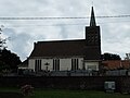
Saint-André church
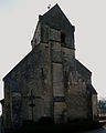
Saint-Maxime church

