
Tournehem-sur-la-Hem
| Tournehem-sur-la-Hem | ||
|---|---|---|
.svg)
|
|
|
| region | Hauts-de-France | |
| Department | Pas-de-Calais | |
| Arrondissement | Saint-Omer | |
| Canton | Saint-Omer | |
| Community association | Pays de Saint-Omer | |
| Coordinates | 50 ° 48 ' N , 2 ° 3' E | |
| height | 22-174 m | |
| surface | 18.14 km 2 | |
| Residents | 1,436 (January 1, 2017) | |
| Population density | 79 inhabitants / km 2 | |
| Post Code | 62890 | |
| INSEE code | 62827 | |

Tournehem-sur-la-Hem (NDL .: "Doornem") is a French municipality with 1436 inhabitants (at January 1, 2017) in the Pas-de-Calais in the region of Hauts-de-France ; it belongs to the Arrondissement of Saint-Omer and the Canton of Saint-Omer .
The municipality is part of the Caps et Marais d'Opale Regional Nature Park .
Population development
- 1962: 831
- 1968: 835
- 1975: 965
- 1982: 1,018
- 1990: 1,069
- 1999: 1,219

Tournehem
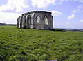
Ruins of the Chapelle Saint-Louis (13th century)


Web links
Commons : Tournehem-sur-la-Hem - collection of images, videos and audio files
Individual evidence
- ^ De Nederlanden in Frankrijk, Jozef van Overstraeten, 1969