
Quiestède
| Quiestède | ||
|---|---|---|

|
|
|
| region | Hauts-de-France | |
| Department | Pas-de-Calais | |
| Arrondissement | Saint-Omer | |
| Canton | Fruges | |
| Community association | Pays de Saint-Omer | |
| Coordinates | 50 ° 41 ′ N , 2 ° 19 ′ E | |
| height | 23-60 m | |
| surface | 2.83 km 2 | |
| Residents | 614 (January 1, 2017) | |
| Population density | 217 inhabitants / km 2 | |
| Post Code | 62120 | |
| INSEE code | 62681 | |
| Website | http://www.mairie-quiestede.fr/ | |
 Quiestède Town Hall |
||

Quiestède ( Flemish : Kierestede ) is a French municipality with 1339 inhabitants (as of January 1 2017) in the department of Pas-de-Calais in the region of Hauts-de-France . It belongs to the Arrondissement of Saint-Omer and the Canton of Fruges .
geography
Quiestède is located about eight kilometers south-southeast of Saint-Omer . The rivers Melde and Laubourne form the northern boundary of the municipality. Quiestède is surrounded by the neighboring communities of Heuringhem in the north and north-west, Racquinghem in the north-east, Roquetoire in the south and east and Ecques in the west and south-west.
Population development
| year | 1962 | 1968 | 1975 | 1982 | 1990 | 1999 | 2006 | 2013 |
| Residents | 335 | 303 | 291 | 402 | 537 | 665 | 649 | 631 |
| Source: Cassini and INSEE | ||||||||
Attractions
- Notre-Dame church from the 16th century
- Laprée Castle, built in 1760, has been a monument historique since 1986
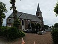
church
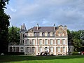
Laprée Castle


Web links
Commons : Quiestède - collection of images, videos and audio files