Longuenesse
| Longuenesse | ||
|---|---|---|

|
|
|
| region | Hauts-de-France | |
| Department | Pas-de-Calais | |
| Arrondissement | Saint-Omer | |
| Canton | Longuenesse (main town) | |
| Community association | Pays de Saint-Omer | |
| Coordinates | 50 ° 44 ' N , 2 ° 14' E | |
| height | 3–79 m | |
| surface | 8.4 km 2 | |
| Residents | 11,023 (January 1, 2017) | |
| Population density | 1,312 inhabitants / km 2 | |
| Post Code | 62219 | |
| INSEE code | 62525 | |
| Website | www.ville-longuenesse.fr/ | |
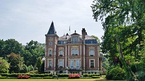
 Mairie from Longueness |
||
Longuenesse ( Flemish : Langenesse ) is a northern French municipality in the Pas-de-Calais department of the Nord-Pas-de-Calais region with 11,023 inhabitants (as of January 1, 2017).
geography
The municipality is located in the metropolitan area of Saint-Omer and is part of the Caps et Marais d'Opale Regional Nature Park .
Longuenesse is surrounded by the neighboring communities of Saint-Martin-au-Laërt (Dutch: "Sint Maartens Aard") in the north, Saint-Omer (Dutch: "Sint Omaars") in the northeast, Arques (Dutch: "Arken") in the east, Blendecques (Dutch: "Blendeke") in the southeast, Wizernes (Dutch: "Wezerne") in the southwest, Wisques in the west and Tatinghem in the northwest. In the southwest of Longuenesse is the Saint-Omer-Wizernes airfield .
history
From 1298 to 1791 a Carthusian monastery was located here ( Chartreuse Val Sainte-Aldegonde ).
Attractions
- The Saint-Quentin church
- Maria Stella Chapel
- Historic Abbey Park
Parish partnership
There is a partnership with the Belgian municipality of Vedrin in the province of Namur.
Web links
Individual evidence
- ^ De Nederlanden in Frankrijk, Jozef van Overstraeten, 1969

