Lumbres
| Lumbres | ||
|---|---|---|

|
|
|
| region | Hauts-de-France | |
| Department | Pas-de-Calais | |
| Arrondissement | Saint-Omer | |
| Canton | Lumbres (main town) | |
| Community association | Pays de Lumbres | |
| Coordinates | 50 ° 42 ′ N , 2 ° 7 ′ E | |
| height | 35-133 m | |
| surface | 9.9 km 2 | |
| Residents | 3,626 (January 1, 2017) | |
| Population density | 366 inhabitants / km 2 | |
| Post Code | 62380 | |
| INSEE code | 62534 | |
| Website | http://www.villedelumbres.fr/ | |
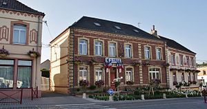
 Mairie (Town Hall) of Lumbres |
||
Lumbres is a French municipality with 3626 inhabitants (as of January 1 2017) in the department of Pas-de-Calais in the region of Hauts-de-France . It belongs to the arrondissement of Saint-Omer and is the main town ( chef-lieu ) of the canton of Lumbres . The inhabitants are called Lumbrois .
geography
Lumbres is on the Aa . The municipality is part of the Caps et Marais d'Opale Regional Nature Park .
Lumbres is surrounded by the neighboring communities of Acquin-Westbécourt in the north and north-west, Quelmes in the north and north-east, Setques in the east, Elnes in the south and south-east, Affringues in the west and south-west and Bayenghem-lès-Seninghem in the north-west. The National Route 42 runs through the municipality .
Population development
| year | 1962 | 1968 | 1975 | 1982 | 1990 | 1999 | 2006 | 2011 |
| Residents | 3,207 | 3,599 | 3,803 | 4,107 | 3,944 | 3,873 | 3,763 | 3,783 |
Attractions
- Saint-Sulpice church, built 1854–1863, Monument historique (since 1980)
- numerous mills
Personalities
- Georges Pointier (1875–1933), prehistorian and paleontologist
- Léon Bence (1929–1987), medic
Web links
Commons : Lumbres - collection of images, videos and audio files
Individual evidence
- ↑ Église Saint-Sulpice in the Base Mérimée of the French Ministry of Culture (French)

