Aa (Pas-de-Calais)
| Aa | ||
|
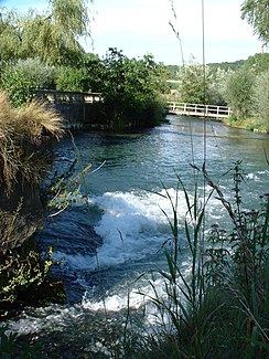
Upper reaches of the Aa in the Pas-de-Calais department |
||
| Data | ||
| Water code | FR : E4030570 , FR : E4--001- | |
| location | France , Hauts-de-France region | |
| River system | Aa | |
| source | in the parish of Bourthes, 50 ° 36 ′ 41 ″ N , 1 ° 55 ′ 54 ″ E |
|
| Source height | approx. 120 m | |
| muzzle | Northeast of Gravelines in the North Sea Coordinates: 51 ° 0 ′ 21 ″ N , 2 ° 6 ′ 17 ″ E 51 ° 0 ′ 21 ″ N , 2 ° 6 ′ 17 ″ E |
|
| Mouth height | 0 m | |
| Height difference | approx. 120 m | |
| Bottom slope | approx. 1.3 ‰ | |
| length | 89 km (see notes) | |
| Left tributaries | Bléquin , Oye | |
| Right tributaries | Moerelak | |
| Small towns | Blendecques , Arques , Saint-Omer , Gravelines | |
| Navigable | between Saint-Omer and the estuary | |
The Aa is a river in northern France , in the Hauts-de-France region .
River course
It rises at a height of about 120 meters 25 kilometers east of the coast of the English Channel in the municipality of Bourthes in the Pas-de-Calais department . From the source it meanders through a hilly landscape in the Regional Nature Park Caps et Marais d'Opale in a mainly north-easterly direction and reaches Saint-Omer . This is where the canalised and strongly straightened lower course begins. After 10 kilometers it reaches the coastal marsh and heads north-north-west to its confluence with the North Sea in the urban area of Gravelines in the Nord department , 89 kilometers of the river from the source. In the canalised section, the border between the two departments runs partly along the river embankments, partly in the river itself.
navigability
At Arques , the Aa meets the Canal de Neuffossé and, downstream from Saint-Omer, as a canalized river, it is itself part of the major shipping route Dunkirk-Scheldt . It is connected to the following shipping channels:
- The connection is made here through a large lock . It raises and lowers the ships by 13 meters and has replaced the Les Fontinettes ship lift since 1967 .
Places on the river
- Bourthes
- Verchocq
- Fauquembergues
- Wavrans-sur-l'Aa
- Lumbres
- Esquerdes
- Hallines
- Wizernes
- Blendecques
- Arques
- Saint-Omer
- Wadding
- Holque
- Gravelines
- Grand Fort Philippe
history
The river gained some notoriety in 1940 because Hitler ordered it as a stop line on the advance on Dunkirk. This enabled the British to evacuate over 300,000 men during the Battle of Dunkirk .
On May 24, 1940, division commander Sepp Dietrich arbitrarily occupied a hill beyond the Aa (Mount Watten, 71 meters) because it offered such a good view (and possibly a shot). Heinz Guderian approved this in retrospect.
Web links
See also
Remarks
- ↑ a b geoportail.fr (1: 16,000)
- ↑ The river length is based on the information on the relevant website sandre.eaufrance.fr/ (river Aa), and sandre.eaufrance.fr/ (canalised Aa), accessed on February 27, 2009, rounded to full kilometers
- ^ Heinz Guderian : Panzer leader. 2nd Da Capo Press edition. Da Capo Press, New York NY 2002, ISBN 0-306-81101-4 , p. 117 below .
