
Mentque-Nortbécourt
| Mentque-Nortbécourt | ||
|---|---|---|

|
|
|
| region | Hauts-de-France | |
| Department | Pas-de-Calais | |
| Arrondissement | Saint-Omer | |
| Canton | Saint-Omer | |
| Community association | Pays de Saint-Omer | |
| Coordinates | 50 ° 47 ' N , 2 ° 5' E | |
| height | 53-163 m | |
| surface | 10.78 km 2 | |
| Residents | 651 (January 1, 2017) | |
| Population density | 60 inhabitants / km 2 | |
| Post Code | 62890 | |
| INSEE code | 62567 | |
| Website | http://www.mentque-nortbecourt.fr/ | |

Mentque-Nortbécourt ( Flemish : Menteke-Noordboekhout ) is a municipality in the north of France with 651 inhabitants (as of January 1, 2017). It belongs to the Hauts-de-France region , the Nord department , the Saint-Omer arrondissement and the Saint-Omer canton (until 2015: Ardres canton ).
geography
Mentque-Nortbécourt is about eleven kilometers west-north-west of Saint-Omer and borders on Nort-Leulinghem in the north, Bayenghem-lès-Éperlecques in the north-east, Houlle in the east and north-east, Moringhem in the south and east, Acquin-Westbécourt in the south-west and Tournehem-sur -la-hem in the west. The municipality is part of the Caps et Marais d'Opale Regional Nature Park .
Population development
| year | 1962 | 1968 | 1975 | 1982 | 1990 | 1999 | 2006 | 2013 |
|---|---|---|---|---|---|---|---|---|
| Residents | 452 | 450 | 404 | 426 | 446 | 449 | 520 | 630 |
| Source: Cassini and INSEE | ||||||||
Attractions
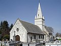
- Saint-Léger-et-Saint-Gilles church in Mentque, originally from the 13th century
- Saint-Wandrille church in Nortbécourt from the 12th century
- Lebriez windmill in Nortbécourt from 1714
- Guilleman windmill
- Inglinghem mill ruins
- Inglinghem Castle

Saint-Léger-et-Saint-Gilles church
Saint-Wandrille Church
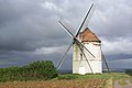
Lebriez windmill
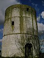
Inglinghem mill ruins


