Elnes
| Elnes | ||
|---|---|---|

|
|
|
| region | Hauts-de-France | |
| Department | Pas-de-Calais | |
| Arrondissement | Saint-Omer | |
| Canton | Lumbres | |
| Community association | Pays de Lumbres | |
| Coordinates | 50 ° 41 ′ N , 2 ° 8 ′ E | |
| height | 40-144 m | |
| surface | 6.33 km 2 | |
| Residents | 914 (January 1, 2017) | |
| Population density | 144 inhabitants / km 2 | |
| Post Code | 62380 | |
| INSEE code | 62292 | |
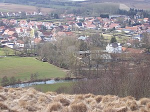
 View of Elnes |
||
Elnes ( Dutch Elne ) is a French municipality with 914 inhabitants (as of January 1, 2017) in the department of Pas-de-Calais in the region of Hauts-de-France . It belongs to the arrondissement of Saint-Omer and the canton of Lumbres .
geography
Elnes is about eleven kilometers southwest of Saint-Omer am Aa . The municipality is part of the Caps et Marais d'Opale Regional Nature Park .
Elnes is surrounded by the neighboring communities Lumbres in the north, Setques in the northeast, Esquerdes in the east and northeast, Wavrans-sur-l'Aa in the south and southeast, Wismes in the west and southwest and Affringues in the west and northwest.
Population development
| year | 1962 | 1968 | 1975 | 1982 | 1990 | 1999 | 2006 | 2013 |
| Residents | 440 | 529 | 666 | 610 | 692 | 721 | 813 | 957 |
| Source: Cassini and INSEE | ||||||||
Attractions
- Saint Martin Church
- lock
Web links
Commons : Elnes - collection of images, videos and audio files
Individual evidence
- ^ De Nederlanden in Frankrijk, Jozef van Overstraeten, 1969
