
Enquin-les-Mines
| Enquin-les-Mines | ||
|---|---|---|

|
|
|
| local community | Enquin-lez-Guinean husband | |
| region | Hauts-de-France | |
| Department | Pas-de-Calais | |
| Arrondissement | Saint-Omer | |
| Coordinates | 50 ° 35 ′ N , 2 ° 17 ′ E | |
| Post Code | 62145 | |
| Former INSEE code | 62295 | |
| Incorporation | January 1, 2017 | |
| status | Commune déléguée | |
| Website | www.enquinlesmines.fr | |
_mairie.JPG) former town hall (Mairie) of Enquin-les-Mines |
||

Enquin-les-Mines ( Dutch sinking ) is a commune Déléguée in the French commune of Enquin-lez-Guinegatte with 1,169 inhabitants (at January 1, 2017) in the Pas-de-Calais in the region of Hauts-de-France .
The municipality of Enquin-les-Mines merged with Enguinegatte on January 1st, 2017 to form the Commune nouvelle Enquin-lez-Guinegatte. It belonged to the arrondissement of Saint-Omer and the canton of Fruges (until 2015: canton of Fauquembergues ).
geography
Enquin-les-Mines is about 22 kilometers south of Saint-Omer and about 16 kilometers west-northwest of Béthune . The municipality of Enquin-les-Mines was surrounded by the neighboring municipalities of Enguinegatte in the north and northwest, Blessy in the northeast, Estrée-Blanche in the east, Rely in the southeast, Fléchin in the south and Erny-Saint-Julien in the west.
Population development
| 1962 | 1968 | 1975 | 1982 | 1990 | 1999 | 2006 | 2013 | |
|---|---|---|---|---|---|---|---|---|
| 1,026 | 944 | 856 | 825 | 869 | 917 | 975 | 1,141 | |
| Source: Cassini and INSEE | ||||||||
Attractions
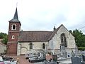
- Saint-Omer church in Enquin from the 15th century
- Saint-Germain church in the hamlet of Serny
- Saint-Wandrille chapel in the locality of Fléchinelle
- Manor of the Knights Templar from the 14th century
- spanish mill
- Serny Mill from 1635

Saint-Omer church

Saint Germain Church
Saint-Wandrille Chapel

Spanish mill
_%C3%A9glise_d%27Enquin,_tour.JPG)
_%C3%A9glise_de_Serny_(02).JPG)
_%C3%A9glise_de_Flechinelle.JPG)
_moulin_espagnol_sur_la_Laquette_(01).JPG)
Web links
Individual evidence
- ^ De Nederlanden in Frankrijk, Jozef van Overstraeten, 1969