Largoz
| Largoz | ||
|---|---|---|
|
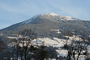
View from Baumkirchen to the Largoz |
||
| height | 2214 m above sea level A. | |
| location | Tyrol , Austria | |
| Mountains | Tux Alps | |
| Dominance | 0.49 km → Wattenspitze | |
| Notch height | 18 m ↓ notch to the Wattenspitze | |
| Coordinates | 47 ° 14 '29 " N , 11 ° 35' 33" E | |
|
|
||
| rock | Metamorphic rocks | |
| Normal way | From the Krepperhütte via the Largozalm | |
The Largoz , also called Glotzen by locals , is the northernmost ridge in the ridge between the Voldertal and the Wattental in the Tux Alps in the Austrian state of Tyrol . The summit cross stands at an altitude of 2214 m above sea level. A. The highest point is over 100 meters further south and reaches a height of at least 2220 m above sea level. A. , but is not listed on the Austrian federal map.
Although the Largoz is only a small notch height to the Wattenspitze further south, 2321 m above sea level. A. , it is the destination of many mountain hikers and ski tourers . The reasons for this are the view from the location directly above the Inn Valley and its easy accessibility. The starting point for an ascent is often the parking lot above the Krepperhütte inn on Großvolderberg at 1360 m above sea level. A. From here you first get to the Largozalm at 1930 m above sea level via a steep path or forest roads . A. , before the path over the Glotzenkreuz at 2092 m above sea level. A. leads up to Largoz.
In winter, Largoz is often climbed on skis. If the snow conditions allow, it is also possible to ski down into the Inn Valley. The car park above the Krepperhütte is also the starting point for a toboggan run in winter, which is prepared on forest paths in the direction of the Largozalm over an altitude difference of around 300 meters.
swell
- ^ Weiss, Rudolf: Skitouren Zillertal Alps, Tux Alps; Steiger Verlag Berwang 1988, ISBN 3-85423-054-0 , p. 59.
- ^ Weiss, Rudolf: Skitouren Zillertal Alps, Tux Alps; Steiger Verlag Berwang 1988, ISBN 3-85423-054-0 , pp. 47, 59.

