Las Gamas
| Las Gamas | ||
|---|---|---|
| Basic data | ||
| Residents (state) | 728 pop. (2012 census) | |
| height | 344 m | |
| Post Code | 07-0201-0300-5001 | |
| Telephone code | (+591) | |
| Coordinates | 17 ° 36 ′ S , 63 ° 1 ′ W | |
|
|
||
| politics | ||
| Department | Santa Cruz | |
| province | Ignacio Warnes Province | |
| climate | ||
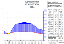
 Climate diagram Warnes |
||
Las Gamas is a town in the Santa Cruz department in the lowlands of the South American Andean state Bolivia .
Location in the vicinity
Las Gamas is the second largest town in the canton of Clara Chuchio in the district ( Bolivian : Municipio ) Warnes in the Ignacio Warnes province in the western part of the Santa Cruz department. The village is located thirteen kilometers northeast of the airport of Santa Cruz , Viru Viru Internacional , at an altitude of 344 m on the Arroyo Los Sauces , which flows further north into the Río Pailon .
geography
Las Gamas is located in the humid tropical climate off the eastern edge of the Andes mountain range of the Cordillera Oriental . The region was covered by subtropical rainforest before colonization , but is now mostly cultivated land .
The mean average temperature of the region is just under 24 ° C (see Warnes climate diagram), the monthly values fluctuate between 20 ° C in June / July and 26 ° C from November to February. The annual precipitation is about 1300 mm, the monthly precipitation is productive and lies between 35 mm in August and 200 mm in January.
Transport network
Las Gamas is 42 kilometers northeast of the capital Santa Cruz and 32 kilometers southeast of the city of Warnes .
By Warnes and Santa Cruz, the 1,657 km long leads highway Ruta 4 , which crosses the country from west to east direction of Tambo Quemado on the Chilean border to Puerto Suárez in the border triangle Brazil -Bolivien- Paraguay . Coming from the west, the road leads via Cochabamba , Villa Tunari and Montero to Warnes and then on via Santa Cruz and Roboré to Puerto Suárez and across the border to Corumbá, Brazil .
Twenty-one kilometers north of Santa Cruz, a country road branches off from Ruta 4 in an easterly direction and reaches Las Gamas via the village of Clara Chuchio after another 21 kilometers .
population
The population of the village has increased by around a third in the past two decades:
| year | Residents | source |
|---|---|---|
| 1992 | 541 | census |
| 2001 | 860 | census |
| 2012 | 728 | census |
In the region, the Quechua are numerically the most important indigenous people , in the municipality of Warnes 13.5 percent of the inhabitants speak the Quechua language.
Individual evidence
- ^ INE - Instituto Nacional de Estadística Bolivia 1992
- ^ INE - Instituto Nacional de Estadística Bolivia 2001
- ↑ INE - Instituto Nacional de Estadística Bolivia 2012 ( Memento of the original from July 22, 2011 in the Internet Archive ) Info: The archive link has been inserted automatically and has not yet been checked. Please check the original and archive link according to the instructions and then remove this notice.
- ↑ INE social data Santa Cruz 2001 (PDF; 5.2 MB)
Web links
- Relief map of the Santa Cruz region 1: 250,000 (PDF; 7.88 MB)
- Municipio Warnes - General Maps No. 70201
- Municipio Warnes - detailed map and population data (PDF; 819 kB) ( Spanish )
- Department Santa Cruz - Social data of the municipalities (PDF; 4.99 MB) ( Spanish )
